Fraud Blocker Skip to main content

Home > Europe > United Kingdom > Scotland > Maps

GGBR2A-00076

GGBR2A-00076
Sold 23
In Stock
We accept all major credit cards

North Wind Photo Prints and Wall Art

GGBR2A-00076

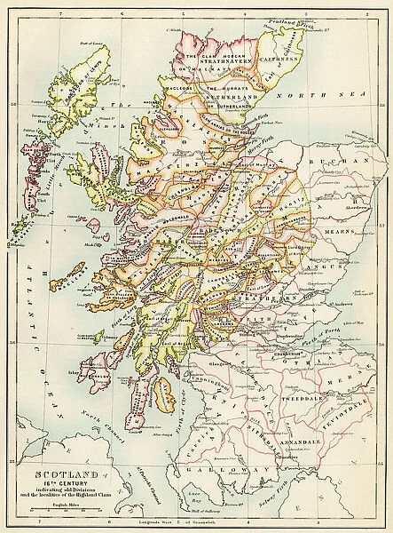
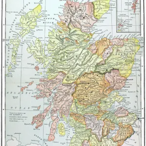
Map of Scotland in the 1520s, showing territories of the Highland Clans.
Printed color lithograph of a 19th century illustration. North Wind Picture Archives brings history to life with stock images and hand-colored illustrations. © North Wind Picture Archives

Media ID 5879160

1500s 16th Century British Europe Great Britain Medieval Scot Scot Land Scottish Territory Clan Highlander Scotch

FEATURES IN THESE COLLECTIONS

> Arts > Art Movements > Medieval Art

> Europe > France > Canton > Landes

> Europe > United Kingdom > Scotland > Highlands > Related Images

> Europe > United Kingdom > Scotland > Maps

> Europe > United Kingdom > Scotland > Posters

> Europe > United Kingdom > Scotland > Related Images

> Maps and Charts > Related Images

> Maps and Charts > Scotland

> North Wind Picture Archives > British history

> North Wind Picture Archives > Maps

SECURE PAYMENTS
We happily accept a wide range of payment options so you can pay for the things you need in the way that is most convenient for you

MADE IN THE USA
Safe Shipping with 30 Day Money Back Guarantee

FREE PERSONALISATION
We are proud to offer a range of customisation including Cropping, Captions, and Filters. Zoom Cropping can be adjusted in the Basket.


EDITORS COMMENTS

This 19th-century lithograph print takes us back in time to the 1520s, offering a glimpse into the territories of the Highland Clans in Scotland. The intricate map showcases the rich history and medieval heritage of this great nation. With its vibrant printed colors, every detail comes to life, transporting us to an era when clans and their territories played a significant role in Scottish society. The illustration provides a fascinating insight into the complex web of clan affiliations and territorial boundaries that defined Scotland during this period. It serves as a visual representation of power struggles, alliances, and cultural identities that shaped the destiny of these proud highlanders. As we explore this vintage artwork, one cannot help but marvel at how it captures both historical accuracy and artistic beauty. The meticulous craftsmanship transports us through time, allowing us to appreciate not only the geography but also the artistry behind cartography during those times. This remarkable piece is more than just an illustration; it is a testament to Scottish history and European artistry. It reminds us of our shared past while igniting curiosity about what life was like for these brave Scots who called themselves highlanders. Whether you are fascinated by genealogy or simply captivated by ancient maps, this print offers an enchanting window into Scotland's past - a treasure for any history enthusiast or lover of fine art alike.


Framed Prints

Introducing the captivating addition to our Framed Prints collection from Media Storehouse: GGBR2A-00076 - A Map of Scotland in the 1520s, showcasing the territories of the Highland Clans. This stunning print is a 19th-century illustration, meticulously reproduced as a color lithograph. Travel back in time as you explore the rich history and intricate details of Scotland's clan lands, beautifully framed and ready to grace your walls. Bring a piece of the past into your home or office, and let this captivating piece ignite your imagination.


Photo Prints

Discover the rich history of Scotland with our exquisite Media Storehouse Photographic Print, featuring the captivating map GGBR2A-00076 from North Wind Picture Archives. This stunning color lithograph showcases an intriguing 1520s map, illustrating the territories of the Highland Clans. Bring the past to life in your home or office by displaying this beautiful and historically significant print. Immerse yourself in the tales of Scotland's proud heritage, as you explore every detail of this captivating illustration from the 19th century.


Poster Prints

Introducing the captivating "GGBR2A-00076" poster print from Media Storehouse, in collaboration with North Wind Picture Archives. This stunning print transports you back in time with an intricately detailed map of Scotland from the year 1520. Explore the territories of the Highland Clans in vibrant color, as depicted in an enchanting 19th century illustration. Revive the rich history of Scotland on your walls and add an element of timeless charm to any room. Experience the past like never before with this beautiful, museum-quality poster print.


Jigsaw Puzzles

Discover the rich history of Scotland with our captivating jigsaw puzzle from Media Storehouse and North Wind Picture Archives. This intriguing puzzle, GGBR2A-00076, showcases an enchanting map of Scotland from the year 1520. Witness the territories of the Highland Clans as they once were, meticulously detailed in a stunning 19th century illustration. Immerse yourself in the intrigue of historical cartography and connect with Scotland's past as you piece together this captivating puzzle. A perfect addition to any home or office, this puzzle offers hours of engaging entertainment for puzzle enthusiasts and history buffs alike. Let the adventure begin!

diamond
Made With High Grade Materials
thumb_up
Professional Quality Finish
package_2
Carefully Packed To Aid Safe Arrival

You May Also Like


Earth map according to HerodotusEarth map according to Herodotus
Add to Basket
Scotland map, 1870sScotland map, 1870s
Add to Basket
Thirteen original colonies in 1776Thirteen original colonies in 1776
Add to Basket
Medieval Europe at the start of the CrusadesMedieval Europe at the start of the Crusades
Add to Basket
Antique map of ScotlandAntique map of Scotland
Add to Basket
Bayeaux Tapestry portraying the Norman ConquestBayeaux Tapestry portraying the Norman Conquest
Add to Basket
MAP: SCOTLAND. Line engraving, 19th centuryMAP: SCOTLAND. Line engraving, 19th century
Add to Basket
Map of ancient RomeMap of ancient Rome
Add to Basket
Ancient Greece and its colonies around the AegeanAncient Greece and its colonies around the Aegean
Add to Basket
Map of England, 1800sMap of England, 1800s
Add to Basket
Map of England in 1066Map of England in 1066
Add to Basket
Antique damaged map of Scotland in the 19th CenturyAntique damaged map of Scotland in the 19th Century
Add to Basket

Gallery Wall Inspiration

Map of England in 1066
Scotland map, 1870s
Bayeaux Tapestry portraying the Norman Conquest
William of Orange at the Battle of the Boyne, 1668
Map of England, 1800s
GGBR2A-00076
Angevin kings holdings in France and Britain
Map of England and France, 1154
Battle of Waterloo, 1815
Medieval knight on horseback
Ireland map, 1870s
Spanish Armada, 1588
Westminster Abbey, London
Warwick Castle
Druid carrying mistletoe
Crystal Palace, London, 1851
Tower of London in the late Middle Ages
Bakers at their trade in the late Middle Ages
Medieval guild seal
Thames River in London, mid-1800s
London street in the 1880s
British army advancing at the Battle of Waterloo, 1815
British riflemen, 1880s
Part of the Magna Carta preamble
Seaport of Plymouth, England
PMYT2A-00017
Duke of Wellington, Arthur Wellesley

Discover Our Collections


British historyBritish history
View Collection
MapsMaps
View Collection
Scotland Related ImagesScotland Related Images
View Collection
Medieval ArtMedieval Art
View Collection
Maps and Charts Related ImagesMaps and Charts Related Images
View Collection
LandesLandes
View Collection
Highlands Related ImagesHighlands Related Images
View Collection
ScotlandScotland
View Collection
MapsMaps
View Collection
PostersPosters
View Collection


© Copyright Media Storehouse, All Rights Reserved 2003 - 2024
Facebook     Pinterest     Card Payments     Reviews IO