Photo Mug > North America > United States of America > South Carolina > Charleston
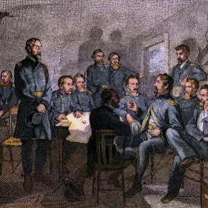
Photo Mug : Map showing location of Fort Sumter, Civil War


![]()
Home Decor From North Wind
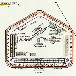
Map showing location of Fort Sumter, Civil War
Chart of Charleston harbor, showing Fort Sumter and Fort Moultrie.
Hand-colored woodcut of a 19th-century illustration
North Wind Picture Archives brings history to life with stock images and hand-colored illustrations
Media ID 5879632
© North Wind Picture Archives
1860 1860s America Charleston Chart Civil War Confederacy Confederate Diagram Fort Fort Moultrie Fort Sumter Harbor Military Rebellion Secession South South Carolina Southern
Large Photo Mug (15 oz)
Add a touch of history to your daily routine with our Media Storehouse Photo Mugs. Featuring an intriguing image from North Wind Picture Archives, this mug showcases a hand-colored woodcut chart of Charleston harbor, highlighting the iconic forts of Fort Sumter and Fort Moultrie. Relive the past as you enjoy your favorite beverage from this high-quality mug, making each sip an educational and enjoyable experience. Perfect for history enthusiasts and collectors, this unique mug is not only functional but also a beautiful conversation starter. Order yours today and bring a piece of the past into your present.
Elevate your coffee or tea experience with our premium white ceramic mug. Its wide, comfortable handle makes drinking easy, and you can rely on it to be both microwave and dishwasher safe. Sold in single units, preview may show both sides of the same mug so you can see how the picture wraps around.
Elevate your coffee or tea experience with our premium white ceramic mug. Its wide, comfortable handle makes drinking easy, and you can rely on it to be both microwave and dishwasher safe. Sold in single units, preview may show both sides of the same mug so you can see how the picture wraps around.
These are individually made so all sizes are approximate
FEATURES IN THESE COLLECTIONS
> North Wind Picture Archives
> Civil War (US)
> North America
> United States of America
> South Carolina
> Charleston
> South America
> Related Images
EDITORS COMMENTS
This hand-colored woodcut print takes us back to the 19th century, providing a glimpse into the historic events of the Civil War. The image showcases a detailed map highlighting the strategic location of Fort Sumter in Charleston Harbor, South Carolina. This chart not only includes Fort Sumter but also features another significant fortification of that time, Fort Moultrie. The artist's intricate illustration skillfully captures the essence of this pivotal moment in American history. With its vintage charm and traditional style, this print serves as a reminder of our nation's military heritage and Southern roots. As we delve deeper into this artwork, we are transported to an era marked by rebellion and secession. It is impossible not to ponder upon the significance of Charleston Harbor during those turbulent times when tensions between North and South America were at their peak. This piece offers a visual narrative that encapsulates both sides of the conflict – Confederate and Union forces – while emphasizing how crucial control over these forts was for each side's strategy. Through its depiction of Fort Sumter and Fort Moultrie on this historical chart from 1860s Charleston SC, it invites us to explore further into one of America's most defining chapters: The Civil War.
MADE IN THE USA
Safe Shipping with 30 Day Money Back Guarantee
FREE PERSONALISATION*
We are proud to offer a range of customisation features including Personalised Captions, Color Filters and Picture Zoom Tools
SECURE PAYMENTS
We happily accept a wide range of payment options so you can pay for the things you need in the way that is most convenient for you
* Options may vary by product and licensing agreement. Zoomed Pictures can be adjusted in the Basket.