Photo Mug > Maps and Charts > Africa
Photo Mug : World Map / Pomponius Mela


![]()
Home Decor from Mary Evans Picture Library
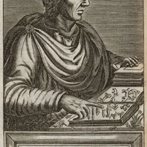
World Map / Pomponius Mela
A world map according to Pomponius Mela, showing Europe, Africa, Asia, and the rest in the lower half
Mary Evans Picture Library makes available wonderful images created for people to enjoy over the centuries
Media ID 608725
© Mary Evans Picture Library 2015 - https://copyrighthub.org/s0/hub1/creation/maryevans/MaryEvansPictureID/10113655
Half Lower Maps Mela Pomponius
Large Photo Mug (15 oz)
Discover the captivating world around you with our Media Storehouse Photo Mugs, featuring the intriguing "World Map / Pomponius Mela" image from Mary Evans Picture Library. This vintage world map, depicting Europe, Africa, Asia, and the unexplored territories in the lower half, is a captivating addition to your daily routine. Each mug holds your favorite beverage, while the high-quality image transfers ensure the vibrant colors and intricate details of the map remain intact. Travel the world from the comfort of your desk or kitchen table, and make every sip an adventure with our Photo Mugs.
Elevate your coffee or tea experience with our premium white ceramic mug. Its wide, comfortable handle makes drinking easy, and you can rely on it to be both microwave and dishwasher safe. Sold in single units, preview may show both sides of the same mug so you can see how the picture wraps around.
Elevate your coffee or tea experience with our premium white ceramic mug. Its wide, comfortable handle makes drinking easy, and you can rely on it to be both microwave and dishwasher safe. Sold in single units, preview may show both sides of the same mug so you can see how the picture wraps around.
These are individually made so all sizes are approximate
FEATURES IN THESE COLLECTIONS
> Africa
> Related Images
> Asia
> Related Images
> Europe
> Related Images
> Maps and Charts
> Early Maps
> Maps and Charts
> Related Images
> Maps and Charts
> World
EDITORS COMMENTS
This world map, titled "Mundus Vetus" or "Old World," is an intriguing representation of geographical knowledge during the ancient Roman era. The map is attributed to Pomponius Mela, a geographer from the 1st century AD. The map depicts the known world at that time, with Europe occupying the upper half and Africa, Asia, and the unexplored southern hemisphere in the lower half. Mela's map is a significant historical artifact, as it provides valuable insights into the geographical understanding of the ancient world. Europe is shown with its major landmasses, including the British Isles, Iberia, Gaul, Italy, and the Danube River. Africa is depicted as a long, narrow continent, stretching from the Mediterranean Sea to the southern tip, with the Nile River running through its center. Asia is shown as a vast landmass, extending from the Caspian Sea in the north to the Indian Ocean in the south. The map also includes various mythical places, such as the "Island of the Blessed" and the "Land of the Eunuchs." The map's cartography is not based on actual explorations but rather on the knowledge available to Mela and other ancient geographers. This map is an essential reminder of the limitations of geographical knowledge during the ancient world and the remarkable progress that has been made since then. This image is a rare and fascinating glimpse into the past, offering a unique perspective on the world as it was understood over 2,000 years ago. The intricate details and vibrant colors of this map make it a captivating work of art and a valuable historical document. The map's age and historical significance make it a must-have for any collection focused on ancient history, cartography, or geography.
MADE IN THE USA
Safe Shipping with 30 Day Money Back Guarantee
FREE PERSONALISATION*
We are proud to offer a range of customisation features including Personalised Captions, Color Filters and Picture Zoom Tools
SECURE PAYMENTS
We happily accept a wide range of payment options so you can pay for the things you need in the way that is most convenient for you
* Options may vary by product and licensing agreement. Zoomed Pictures can be adjusted in the Cart.