Metal Print > Maps and Charts > Africa
Metal Print : World Map / Pomponius Mela


![]()
Metal Prints from Mary Evans Picture Library
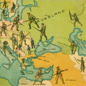
World Map / Pomponius Mela
A world map according to Pomponius Mela, showing Europe, Africa, Asia, and the rest in the lower half
Mary Evans Picture Library makes available wonderful images created for people to enjoy over the centuries
Media ID 608725
© Mary Evans Picture Library 2015 - https://copyrighthub.org/s0/hub1/creation/maryevans/MaryEvansPictureID/10113655
Half Lower Maps Mela Pomponius
20"x24" (61x51cm) Metal Print
Discover the captivating allure of the past with our Media Storehouse Metal Prints featuring the intriguing World Map by Pomponius Mela from Mary Evans Picture Library. This exquisite map, sourced from Mary Evans Prints Online, showcases a captivating representation of the ancient world as it was known to Pomponius Mela around 43 AD. With Europe, Africa, and Asia depicted in stunning detail in the upper half, and the lower half revealing the mysteries of the unknown world, this metal print is a mesmerizing addition to any space. Each print is meticulously crafted using high-quality metal sheets, ensuring a vibrant and long-lasting display. Transport yourself back in time and add a touch of history to your home or office with our Media Storehouse Metal Prints.
Made with durable metal and luxurious printing techniques, our metal photo prints go beyond traditional canvases, adding a cool, modern touch to your space. Wall mount on back. Eco-friendly 100% post-consumer recycled ChromaLuxe aluminum surface. The thickness of the print is 0.045". Featuring a Scratch-resistant surface and Rounded corners. Backing hangers are attached to the back of the print and float the print 1/2-inch off the wall when hung, the choice of hanger may vary depending on size and International orders will come with Float Mount hangers only. Finished with a brilliant white high gloss surface for unsurpassed detail and vibrance. Printed using Dye-Sublimation and for best care we recommend a non-ammonia glass cleaner, water, or isopropyl (rubbing) alcohol to prevent harming the print surface. We recommend using a clean, lint-free cloth to wipe off the print. The ultra-hard surface is scratch-resistant, waterproof and weatherproof. Avoid direct sunlight exposure.
Made with durable metal and luxurious printing techniques, metal prints bring images to life and add a modern touch to any space
Estimated Image Size (if not cropped) is 50.8cm x 60.9cm (20" x 24")
Estimated Product Size is 51.4cm x 61.5cm (20.2" x 24.2")
These are individually made so all sizes are approximate
Artwork printed orientated as per the preview above, with portrait (vertical) orientation to match the source image.
FEATURES IN THESE COLLECTIONS
> Africa
> Related Images
> Asia
> Related Images
> Europe
> Related Images
> Maps and Charts
> Early Maps
> Maps and Charts
> Related Images
> Maps and Charts
> World
EDITORS COMMENTS
This world map, titled "Mundus Vetus" or "Old World," is an intriguing representation of geographical knowledge during the ancient Roman era. The map is attributed to Pomponius Mela, a geographer from the 1st century AD. The map depicts the known world at that time, with Europe occupying the upper half and Africa, Asia, and the unexplored southern hemisphere in the lower half. Mela's map is a significant historical artifact, as it provides valuable insights into the geographical understanding of the ancient world. Europe is shown with its major landmasses, including the British Isles, Iberia, Gaul, Italy, and the Danube River. Africa is depicted as a long, narrow continent, stretching from the Mediterranean Sea to the southern tip, with the Nile River running through its center. Asia is shown as a vast landmass, extending from the Caspian Sea in the north to the Indian Ocean in the south. The map also includes various mythical places, such as the "Island of the Blessed" and the "Land of the Eunuchs." The map's cartography is not based on actual explorations but rather on the knowledge available to Mela and other ancient geographers. This map is an essential reminder of the limitations of geographical knowledge during the ancient world and the remarkable progress that has been made since then. This image is a rare and fascinating glimpse into the past, offering a unique perspective on the world as it was understood over 2,000 years ago. The intricate details and vibrant colors of this map make it a captivating work of art and a valuable historical document. The map's age and historical significance make it a must-have for any collection focused on ancient history, cartography, or geography.
MADE IN THE USA
Safe Shipping with 30 Day Money Back Guarantee
FREE PERSONALISATION*
We are proud to offer a range of customisation features including Personalised Captions, Color Filters and Picture Zoom Tools
SECURE PAYMENTS
We happily accept a wide range of payment options so you can pay for the things you need in the way that is most convenient for you
* Options may vary by product and licensing agreement. Zoomed Pictures can be adjusted in the Cart.