Photo Mug > Maps and Charts > British Empire Maps
Photo Mug : WORLD MAP / 1897


![]()
Home Decor from Mary Evans Picture Library
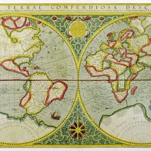
WORLD MAP / 1897
Map of the world showing British Empire possessions
Mary Evans Picture Library makes available wonderful images created for people to enjoy over the centuries
Media ID 585188
© Mary Evans Picture Library 2015 - https://copyrighthub.org/s0/hub1/creation/maryevans/MaryEvansPictureID/10039195
1897 Colonialism Imperialism Possessions
Large Photo Mug (15 oz)
Introducing the Media Storehouse Photo Mug, a unique and thoughtful gift that lets you take your favorite images with you everywhere you go. This mug features an intriguing historical image from Mary Evans Picture Library, showcasing a world map from 1897, displaying the vast expanse of the British Empire at the time. Travel back in history with every sip of your coffee or tea. The high-quality print ensures vibrant colors and sharp details, making this mug not only a functional but also an eye-catching addition to your collection. Perfect for history enthusiasts, world travelers, or anyone who appreciates the beauty of vintage maps, this Photo Mug is sure to impress. Order yours today and make your daily beverage routine a journey through time.
Elevate your coffee or tea experience with our premium white ceramic mug. Its wide, comfortable handle makes drinking easy, and you can rely on it to be both microwave and dishwasher safe. Sold in single units, preview may show both sides of the same mug so you can see how the picture wraps around.
Elevate your coffee or tea experience with our premium white ceramic mug. Its wide, comfortable handle makes drinking easy, and you can rely on it to be both microwave and dishwasher safe. Sold in single units, preview may show both sides of the same mug so you can see how the picture wraps around.
These are individually made so all sizes are approximate
FEATURES IN THESE COLLECTIONS
> Mary Evans Prints Online
> Maps
> Maps and Charts
> British Empire Maps
> Maps and Charts
> Early Maps
> Maps and Charts
> Related Images
> Maps and Charts
> World
EDITORS COMMENTS
This stunning print of a world map from 1897 offers a fascinating glimpse into the era of imperialism and colonialism. The map vividly displays the vast extent of the British Empire's possessions at the height of its power, showcasing territories spread across continents and oceans.
Each shaded region on the map represents an area under British control, highlighting the global reach and influence of this once mighty empire. From India to Africa to Australia, the British Empire's presence is unmistakable, with each possession symbolizing a complex history of conquest, exploitation, and cultural exchange.
As we study this historical map, we are reminded of the political dynamics that shaped our modern world. The lines drawn on this map reflect not just geographical boundaries but also centuries-old power struggles and conflicts between nations. It serves as a visual reminder of how imperialism reshaped societies and landscapes around the globe.
This print is not just a decorative piece but also a valuable educational tool for understanding our shared history. It prompts us to reflect on past injustices while also appreciating the interconnectedness of our world today. A truly captivating piece that invites viewers to explore both geography and politics through a historical lens.
MADE IN THE USA
Safe Shipping with 30 Day Money Back Guarantee
FREE PERSONALISATION*
We are proud to offer a range of customisation features including Personalised Captions, Color Filters and Picture Zoom Tools
SECURE PAYMENTS
We happily accept a wide range of payment options so you can pay for the things you need in the way that is most convenient for you
* Options may vary by product and licensing agreement. Zoomed Pictures can be adjusted in the Cart.