Fine Art Print > Maps and Charts > British Empire Maps
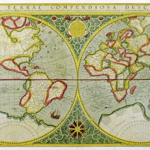
Fine Art Print : WORLD MAP / 1897


![]()
Fine Art Prints from Mary Evans Picture Library
WORLD MAP / 1897
Map of the world showing British Empire possessions
Mary Evans Picture Library makes available wonderful images created for people to enjoy over the centuries
Media ID 585188
© Mary Evans Picture Library 2015 - https://copyrighthub.org/s0/hub1/creation/maryevans/MaryEvansPictureID/10039195
1897 Colonialism Imperialism Possessions
21"x14" (+3" Border) Fine Art Print
Discover the rich history and expansive reach of the British Empire with our exquisite fine art print of 'World Map / 1897' from Mary Evans Picture Library. This captivating vintage map, available through Media Storehouse, showcases the extent of the British Empire at the turn of the 20th century. The intricate details and vibrant colors bring history to life, making this a stunning addition to any home or office. Order your print today and embark on a journey through time.
21x14 image printed on 27x20 Fine Art Rag Paper with 3" (76mm) white border. Our Fine Art Prints are printed on 300gsm 100% acid free, PH neutral paper with archival properties. This printing method is used by museums and art collections to exhibit photographs and art reproductions.
Our fine art prints are high-quality prints made using a paper called Photo Rag. This 100% cotton rag fibre paper is known for its exceptional image sharpness, rich colors, and high level of detail, making it a popular choice for professional photographers and artists. Photo rag paper is our clear recommendation for a fine art paper print. If you can afford to spend more on a higher quality paper, then Photo Rag is our clear recommendation for a fine art paper print.
Estimated Image Size (if not cropped) is 53.3cm x 34.2cm (21" x 13.5")
Estimated Product Size is 68.6cm x 50.8cm (27" x 20")
These are individually made so all sizes are approximate
Artwork printed orientated as per the preview above, with landscape (horizontal) orientation to match the source image.
FEATURES IN THESE COLLECTIONS
> Maps and Charts
> British Empire Maps
> Maps and Charts
> Early Maps
> Maps and Charts
> Related Images
> Maps and Charts
> World
> Mary Evans Prints Online
> Maps
EDITORS COMMENTS
This stunning print of a world map from 1897 offers a fascinating glimpse into the era of imperialism and colonialism. The map vividly displays the vast extent of the British Empire's possessions at the height of its power, showcasing territories spread across continents and oceans.
Each shaded region on the map represents an area under British control, highlighting the global reach and influence of this once mighty empire. From India to Africa to Australia, the British Empire's presence is unmistakable, with each possession symbolizing a complex history of conquest, exploitation, and cultural exchange.
As we study this historical map, we are reminded of the political dynamics that shaped our modern world. The lines drawn on this map reflect not just geographical boundaries but also centuries-old power struggles and conflicts between nations. It serves as a visual reminder of how imperialism reshaped societies and landscapes around the globe.
This print is not just a decorative piece but also a valuable educational tool for understanding our shared history. It prompts us to reflect on past injustices while also appreciating the interconnectedness of our world today. A truly captivating piece that invites viewers to explore both geography and politics through a historical lens.
MADE IN THE USA
Safe Shipping with 30 Day Money Back Guarantee
FREE PERSONALISATION*
We are proud to offer a range of customisation features including Personalised Captions, Color Filters and Picture Zoom Tools
SECURE PAYMENTS
We happily accept a wide range of payment options so you can pay for the things you need in the way that is most convenient for you
* Options may vary by product and licensing agreement. Zoomed Pictures can be adjusted in the Cart.