Photo Mug > Maps and Charts > World
Photo Mug : Europe Map C1914


Home Decor from Mary Evans Picture Library
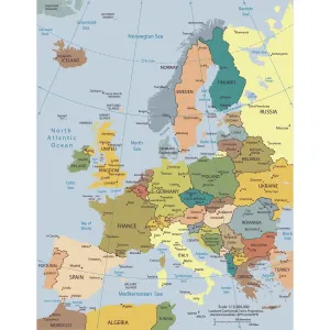
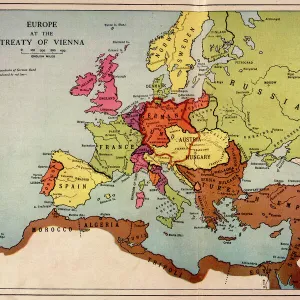
Europe Map C1914
The map of Europe on the eve of World War One
Mary Evans Picture Library makes available wonderful images created for people to enjoy over the centuries
Media ID 4315925
© Mary Evans Picture Library 2015 - https://copyrighthub.org/s0/hub1/creation/maryevans/MaryEvansPictureID/10125199
Large Photo Mug (15 oz)
Introducing the Media Storehouse Europe Map C1914 Photo Mug, a unique and captivating addition to your collection. This premium mug showcases an iconic image of Europe on the eve of World War One, taken from the extensive archive of Mary Evans Prints Online. The intricate details of the map are beautifully depicted, making each sip an opportunity to explore history. Ideal for history enthusiasts, travelers, or anyone with a love for vintage maps, this mug is not just a drinkware, but a conversation starter. Embrace the past, brew your favorite beverage, and embark on a journey through time with every use.
Elevate your coffee or tea experience with our premium white ceramic mug. Its wide, comfortable handle makes drinking easy, and you can rely on it to be both microwave and dishwasher safe. Sold in single units, preview may show both sides of the same mug so you can see how the picture wraps around.
Elevate your coffee or tea experience with our premium white ceramic mug. Its wide, comfortable handle makes drinking easy, and you can rely on it to be both microwave and dishwasher safe. Sold in single units, preview may show both sides of the same mug so you can see how the picture wraps around.
These are individually made so all sizes are approximate
FEATURES IN THESE COLLECTIONS
> Europe
> Related Images
> Maps and Charts
> Early Maps
> Maps and Charts
> Popular Maps
> Maps and Charts
> Related Images
> Maps and Charts
> World
> Popular Themes
> Maps and Charts
EDITORS COMMENTS
This stunning print of the Europe Map circa 1914 captures a pivotal moment in history, just on the eve of World War One. The intricate details and borders of each country are beautifully depicted, showcasing the political landscape of Europe at that time. As we gaze upon this map, we can almost feel the tension and uncertainty that loomed over the continent before the outbreak of one of the deadliest conflicts in human history.
The colors and design of this map transport us back to a time when alliances were shifting, empires were crumbling, and nations were on edge. It serves as a powerful reminder of how quickly peace can unravel into chaos and conflict.
As we study this map closely, we can see how interconnected yet divided Europe was in 1914. Each country represented had its own ambitions, fears, and aspirations - all factors that would eventually contribute to the outbreak of World War One.
This print is not just a historical artifact; it is a visual representation of a world on the brink of destruction. It reminds us to never take peace for granted and to always strive for diplomacy over war.
MADE IN THE USA
Safe Shipping with 30 Day Money Back Guarantee
FREE PERSONALISATION*
We are proud to offer a range of customisation features including Personalised Captions, Color Filters and Picture Zoom Tools
SECURE PAYMENTS
We happily accept a wide range of payment options so you can pay for the things you need in the way that is most convenient for you
* Options may vary by product and licensing agreement. Zoomed Pictures can be adjusted in the Cart.