Metal Print > Maps and Charts > World
Metal Print : Europe Map C1914


Metal Prints from Mary Evans Picture Library
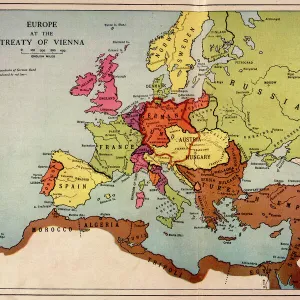
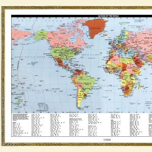
Europe Map C1914
The map of Europe on the eve of World War One
Mary Evans Picture Library makes available wonderful images created for people to enjoy over the centuries
Media ID 4315925
© Mary Evans Picture Library 2015 - https://copyrighthub.org/s0/hub1/creation/maryevans/MaryEvansPictureID/10125199
16"x24" (61x41cm) Metal Print
Step back in time with our stunning Europe Map C1914 Metal Print from Media Storehouse. This exquisite piece, sourced from Mary Evans Prints Online, transports you to the eve of World War One with intricate detail and vintage charm. The classic European map design is meticulously printed onto high-quality metal, ensuring vibrant colors and exceptional durability. Add a touch of history and elegance to your space with this unique and captivating addition to your decor.
Made with durable metal and luxurious printing techniques, our metal photo prints go beyond traditional canvases, adding a cool, modern touch to your space. Wall mount on back. Eco-friendly 100% post-consumer recycled ChromaLuxe aluminum surface. The thickness of the print is 0.045". Featuring a Scratch-resistant surface and Rounded corners. Backing hangers are attached to the back of the print and float the print 1/2-inch off the wall when hung, the choice of hanger may vary depending on size and International orders will come with Float Mount hangers only. Finished with a brilliant white high gloss surface for unsurpassed detail and vibrance. Printed using Dye-Sublimation and for best care we recommend a non-ammonia glass cleaner, water, or isopropyl (rubbing) alcohol to prevent harming the print surface. We recommend using a clean, lint-free cloth to wipe off the print. The ultra-hard surface is scratch-resistant, waterproof and weatherproof. Avoid direct sunlight exposure.
Made with durable metal and luxurious printing techniques, metal prints bring images to life and add a modern touch to any space
Estimated Product Size is 61.5cm x 41.2cm (24.2" x 16.2")
These are individually made so all sizes are approximate
Artwork printed orientated as per the preview above, with landscape (horizontal) orientation to match the source image.
FEATURES IN THESE COLLECTIONS
> Europe
> Related Images
> Maps and Charts
> Early Maps
> Maps and Charts
> Popular Maps
> Maps and Charts
> Related Images
> Maps and Charts
> World
> Popular Themes
> Maps and Charts
EDITORS COMMENTS
This stunning print of the Europe Map circa 1914 captures a pivotal moment in history, just on the eve of World War One. The intricate details and borders of each country are beautifully depicted, showcasing the political landscape of Europe at that time. As we gaze upon this map, we can almost feel the tension and uncertainty that loomed over the continent before the outbreak of one of the deadliest conflicts in human history.
The colors and design of this map transport us back to a time when alliances were shifting, empires were crumbling, and nations were on edge. It serves as a powerful reminder of how quickly peace can unravel into chaos and conflict.
As we study this map closely, we can see how interconnected yet divided Europe was in 1914. Each country represented had its own ambitions, fears, and aspirations - all factors that would eventually contribute to the outbreak of World War One.
This print is not just a historical artifact; it is a visual representation of a world on the brink of destruction. It reminds us to never take peace for granted and to always strive for diplomacy over war.
MADE IN THE USA
Safe Shipping with 30 Day Money Back Guarantee
FREE PERSONALISATION*
We are proud to offer a range of customisation features including Personalised Captions, Color Filters and Picture Zoom Tools
SECURE PAYMENTS
We happily accept a wide range of payment options so you can pay for the things you need in the way that is most convenient for you
* Options may vary by product and licensing agreement. Zoomed Pictures can be adjusted in the Cart.