Photo Mug > Animals > Mammals > Muridae > Fortior
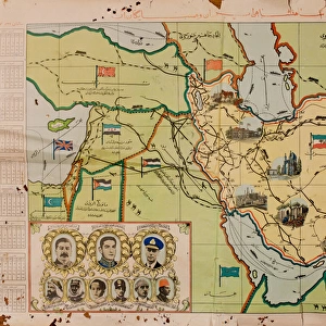
Photo Mug : Arabic writing on a map of Italy and North Africa, WW2


![]()
Home Decor From Mary Evans Picture Library
Arabic writing on a map of Italy and North Africa, WW2
Arabic writing on a map of Italy and North Africa during the Second World War.
1940s
Mary Evans Picture Library makes available wonderful images created for people to enjoy over the centuries
Media ID 14412705
© Mary Evans Picture Library/Onslow Auctions Limited
Large Photo Mug (15 oz)
Step back in time with our unique Media Storehouse Photo Mug featuring an intriguing image from the Mary Evans Picture Library/Onslow Auctions Limited. This vintage map of Italy and North Africa, adorned with Arabic writing from the 1940s, transports you to a bygone era during the Second World War. Each mug in the Media Storehouse Photo Mug range showcases high-quality prints that bring history to life, making them perfect for history enthusiasts or as thoughtful gifts. Embrace the past with every sip.
Elevate your coffee or tea experience with our premium white ceramic mug. Its wide, comfortable handle makes drinking easy, and you can rely on it to be both microwave and dishwasher safe. Sold in single units, preview may show both sides of the same mug so you can see how the picture wraps around.
Elevate your coffee or tea experience with our premium white ceramic mug. Its wide, comfortable handle makes drinking easy, and you can rely on it to be both microwave and dishwasher safe. Sold in single units, preview may show both sides of the same mug so you can see how the picture wraps around.
These are individually made so all sizes are approximate
FEATURES IN THESE COLLECTIONS
> Animals
> Mammals
> Muridae
> Fortior
> Europe
> Italy
> Sicily
> Related Images
> Historic
> World War I and II
> World War II
EDITORS COMMENTS
This evocative image captures the complex geopolitical landscape of the Mediterranean during the Second World War, as depicted in an intriguing vintage map of Italy and North Africa. Dated to the 1940s, the map is adorned with Arabic text, reflecting the significant influence of the Middle Eastern powers in the region at the time. The map reveals the territorial claims of various European and Allied powers, including Italy, France, and the United Kingdom. The Italian peninsula is prominently marked, with the boot-shaped country's colonies in Libya, Somaliland, and Ethiopia clearly indicated. The map also highlights the strategic importance of Sicily, which was invaded by the Allies in July 1943, leading to the eventual downfall of Benito Mussolini's regime. The North African coastline is also marked with French and British territories, reflecting the longstanding colonial rivalries between these European powers. The map further underscores the multifaceted nature of the conflict, with various flags representing the Allied and Axis forces. The Arabic text on the map adds an intriguing layer to the historical narrative, hinting at the complex cultural and political dynamics at play during this tumultuous period. The map serves as a poignant reminder of the far-reaching consequences of the Second World War, which reshaped the political landscape of Europe and the Middle East for decades to come.
MADE IN THE USA
Safe Shipping with 30 Day Money Back Guarantee
FREE PERSONALISATION*
We are proud to offer a range of customisation features including Personalised Captions, Color Filters and Picture Zoom Tools
SECURE PAYMENTS
We happily accept a wide range of payment options so you can pay for the things you need in the way that is most convenient for you
* Options may vary by product and licensing agreement. Zoomed Pictures can be adjusted in the Basket.