Home > Maps and Charts > World
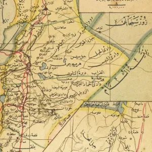
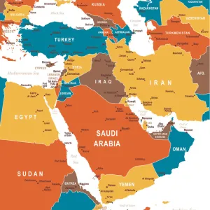
Arabic map of Middle East with heads of state, WW2

![]()
Wall Art and Photo Gifts from Mary Evans Picture Library
Arabic map of Middle East with heads of state, WW2
Arabic map of Middle East with heads of state during the Second World War.
1940s
Mary Evans Picture Library makes available wonderful images created for people to enjoy over the centuries
Media ID 14412699
© Mary Evans Picture Library/Onslow Auctions Limited
EDITORS COMMENTS
This vintage print showcases an intricately detailed Arabic map of the Middle East during the momentous period of the Second World War in the 1940s. The map, adorned with the flags and names of various Arabic-speaking countries, is a testament to the rich history and complex geopolitical landscape of the region during this pivotal time in world history. Surrounding the map are the portraits of the heads of state from several Middle Eastern countries, each man exuding a sense of authority and determination. Among them are King Farouk I of Egypt, King Abdullah I of Transjordan, and King Ibn Saud of Saudi Arabia. Their presence adds a personal touch to the map, humanizing the political landscape and offering a glimpse into the individuals who shaped the region during the war. The Second World War brought significant change to the Middle East, with many countries aligning themselves with the Allied Powers or the Axis Powers. The map and the portraits serve as a poignant reminder of this era, as well as the complex alliances and shifting political dynamics that characterized the region during the 1940s. This print, offered by Mary Evans Picture Library/Onslow Auctions Limited from Mary Evans Prints Online, is an essential addition to any collection focused on Middle Eastern history, cartography, or the Second World War. Its intricate details and historical significance make it a must-have for scholars, historians, and enthusiasts alike.
MADE IN THE USA
Safe Shipping with 30 Day Money Back Guarantee
FREE PERSONALISATION*
We are proud to offer a range of customisation features including Personalised Captions, Color Filters and Picture Zoom Tools
SECURE PAYMENTS
We happily accept a wide range of payment options so you can pay for the things you need in the way that is most convenient for you
* Options may vary by product and licensing agreement. Zoomed Pictures can be adjusted in the Cart.