Photo Mug > Arts > Photorealistic artworks > Detailed art pieces > Masterful detailing in art
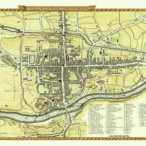
Photo Mug : Old Map of Chester 1805 by Cole and Roper


![]()
Home Decor From MapSeeker
Old Map of Chester 1805 by Cole and Roper
An attractive and detailed early 19th century reproduction town plan of Chester 1805. First published by Cole and Roper as a finely engraved series of county maps and town plans which were initially issued in parts and then together as The British Atlas in 1810
Welcome to the Mapseeker Image library and enter an historic gateway to one of the largest on-line collections of Historic Maps, Nostalgic Views, Vista's and Panorama's from a World gone by.
Media ID 20348062
© Mapseeker Publishing Ltd
Cole And Roper Historic Map Old Town Plan Town Plan Chester
Large Photo Mug (15 oz)
Bring a piece of historical Chester right to your desk with our Media Storehouse Photo Mug featuring an old map of the city from 1805. This beautifully detailed reproduction, first published by Cole and Roper as part of their finely engraved series of county maps, showcases the Old Map of Chester in all its glory. The Old Map of Chester 1805 by Cole and Roper, sourced from MapSeeker, is now transformed into a functional and stylish mug that's perfect for sipping your favorite beverage while you take a journey back in time. Add this unique and captivating mug to your collection and enjoy the rich history of Chester with every sip.
Elevate your coffee or tea experience with our premium white ceramic mug. Its wide, comfortable handle makes drinking easy, and you can rely on it to be both microwave and dishwasher safe. Sold in single units, preview may show both sides of the same mug so you can see how the picture wraps around.
Elevate your coffee or tea experience with our premium white ceramic mug. Its wide, comfortable handle makes drinking easy, and you can rely on it to be both microwave and dishwasher safe. Sold in single units, preview may show both sides of the same mug so you can see how the picture wraps around.
These are individually made so all sizes are approximate
FEATURES IN THESE COLLECTIONS
> Arts
> Photorealistic artworks
> Detailed art pieces
> Masterful detailing in art
> Maps and Charts
> Early Maps
EDITORS COMMENTS
This print showcases an exquisite reproduction of the "Old Map of Chester 1805" by Cole and Roper. Transporting us back to the early 19th century, this town plan offers a mesmerizing glimpse into the historic city of Chester. With its intricate details and attractive engravings, this map provides a fascinating insight into the layout and structure of Chester during that era. Originally published as part of a series of county maps and town plans by Cole and Roper, it was later included in The British Atlas in 1810. Every corner of this ancient city is meticulously depicted on this map, allowing us to explore its winding streets, charming neighborhoods, and iconic landmarks. From the majestic walls encircling the city to the bustling market squares teeming with life, every element is captured with precision. As we delve into this old town plan, we are transported through time to experience what life might have been like for residents in 1805 Chester. It serves as a testament to both historical accuracy and artistic craftsmanship. Whether you are an avid history enthusiast or simply captivated by cartography's beauty, this print is sure to be a cherished addition to any collection. Let yourself be immersed in nostalgia as you admire this remarkable piece that celebrates both Chester's rich heritage and Cole and Roper's exceptional workmanship.
MADE IN THE USA
Safe Shipping with 30 Day Money Back Guarantee
FREE PERSONALISATION*
We are proud to offer a range of customisation features including Personalised Captions, Color Filters and Picture Zoom Tools
SECURE PAYMENTS
We happily accept a wide range of payment options so you can pay for the things you need in the way that is most convenient for you
* Options may vary by product and licensing agreement. Zoomed Pictures can be adjusted in the Basket.