Photo Mug > Europe > France > Maps
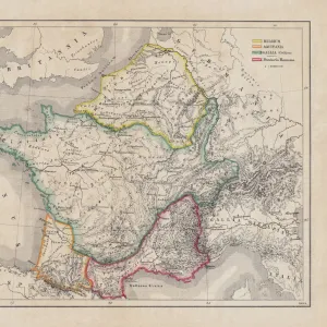
Photo Mug : Map of Arles and Cette, France


![]()
Home Decor From Liszt Collection
Map of Arles and Cette, France
Liszt Collection of nineteenth-century engravings and images to browse and enjoy
Media ID 12974979
© Quint Lox Limited
Large Photo Mug (15 oz)
Bring a piece of the picturesque French Riviera into your daily routine with our Media Storehouse Photo Mug featuring the stunning Map of Arles and Cette, France from the Liszt Collection. This high-quality mug showcases the intricate details of the map, transporting you to the beautiful landscapes of the South of France with every sip. Perfect for coffee or tea, this mug is not only a functional addition to your kitchen but also a unique and thoughtful gift for map lovers and Francophiles alike. Embrace the charm of Arles and Cette with every use.
Elevate your coffee or tea experience with our premium white ceramic mug. Its wide, comfortable handle makes drinking easy, and you can rely on it to be both microwave and dishwasher safe. Sold in single units, preview may show both sides of the same mug so you can see how the picture wraps around.
Elevate your coffee or tea experience with our premium white ceramic mug. Its wide, comfortable handle makes drinking easy, and you can rely on it to be both microwave and dishwasher safe. Sold in single units, preview may show both sides of the same mug so you can see how the picture wraps around.
These are individually made so all sizes are approximate
FEATURES IN THESE COLLECTIONS
> Liszt Collection
> Engravings
> France
> Maps and Charts
> Related Images
EDITORS COMMENTS
This vintage print titled "Map of Arles and Cette, France" takes us on a journey back in time to the enchanting nineteenth century. The intricate engravement technique used to create this piece showcases the remarkable illustrative skills of that era. With its retro-styled appeal, it effortlessly transports us to a bygone era filled with rich history and cultural significance. The map itself is a fascinating depiction of two iconic French cities - Arles and Cette. Every detail has been meticulously etched onto the paper, allowing us to explore these towns as they were centuries ago. From the winding streets and charming architecture to the bustling ports and majestic landmarks, this map offers an immersive experience into the past. As we gaze upon this artwork, we can't help but appreciate how it encapsulates both artistry and historical documentation. Its Victorian aesthetic adds an extra layer of charm, making it a perfect addition for any lover of arts or culture. Whether you're an avid collector or simply someone who appreciates nostalgia, this print from Liszt Collection captures the essence of a forgotten time in French history. It serves as a reminder that even in our fast-paced modern world, there's always room for reflection on our roots and appreciation for traditional craftsmanship.
MADE IN THE USA
Safe Shipping with 30 Day Money Back Guarantee
FREE PERSONALISATION*
We are proud to offer a range of customisation features including Personalised Captions, Color Filters and Picture Zoom Tools
SECURE PAYMENTS
We happily accept a wide range of payment options so you can pay for the things you need in the way that is most convenient for you
* Options may vary by product and licensing agreement. Zoomed Pictures can be adjusted in the Basket.