Photo Mug > Europe > Italy > Maps
Photo Mug : Map of Northern Italy illustrating the campaigns of 1796-1797


![]()
Home Decor from Fine Art Storehouse
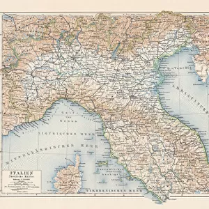
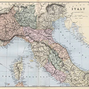
Map of Northern Italy illustrating the campaigns of 1796-1797
Vintage engraving of a Map of Northern Italy illustrating the campaigns of 1796-1797 during the French Revolutionary Wars
Unleash your creativity and transform your space into a visual masterpiece!
duncan1890
Media ID 13667083
© duncan1890
18th Century 18th Century Style 78272 94456 French Revolution Historical War Event Image Created 18th Century Military Military Invasion Navigational Equipment Northern Italy Revolution Southern Europe Styles
Large Photo Mug (15 oz)
Step back in time with our exclusive Media Storehouse Photo Mug, featuring a captivating vintage engraving of a Map of Northern Italy from the Fine Art Storehouse collection. This beautifully detailed illustration showcases the campaigns of 1796-1797 during the French Revolutionary Wars by duncan1890. Each mug holds your favorite beverage while transporting you to a bygone era. Perfect for history enthusiasts, collectors, or anyone who appreciates the intricacy of historical maps, this mug is a must-have addition to your kitchen or office collection. Embrace the past, one sip at a time.
Elevate your coffee or tea experience with our premium white ceramic mug. Its wide, comfortable handle makes drinking easy, and you can rely on it to be both microwave and dishwasher safe. Sold in single units, preview may show both sides of the same mug so you can see how the picture wraps around.
Elevate your coffee or tea experience with our premium white ceramic mug. Its wide, comfortable handle makes drinking easy, and you can rely on it to be both microwave and dishwasher safe. Sold in single units, preview may show both sides of the same mug so you can see how the picture wraps around.
These are individually made so all sizes are approximate
FEATURES IN THESE COLLECTIONS
> Fine Art Storehouse
> Map
> Historical Maps
> Fine Art Storehouse
> Map
> Italian Maps
> Europe
> Italy
> Related Images
> Europe
> Related Images
> Maps and Charts
> Early Maps
> Maps and Charts
> Italy
> Maps and Charts
> Related Images
EDITORS COMMENTS
This vintage engraving of a Map of Northern Italy takes us back to the tumultuous campaigns of 1796-1797 during the French Revolutionary Wars. With its intricate details and 18th-century style, this historical artifact offers a glimpse into a pivotal moment in European history. The map showcases the military invasion that unfolded as France sought to expand its revolutionary ideals beyond its borders. It highlights key cities, strategic routes, and territorial divisions, providing valuable insights into the tactics employed by both sides during this conflict. As we examine this antique engraved image, we are transported to an era where cartography was not only a navigational tool but also an art form. The meticulous craftsmanship and attention to detail demonstrate the importance placed on accurate representation in understanding geographical landscapes. Beyond its practical use, this illustration serves as a visual testament to the power struggles that shaped Europe's past. It reminds us of how wars have influenced political boundaries and reshaped societies throughout history. Whether you are fascinated by military history or simply appreciate fine art from centuries past, this print is sure to spark curiosity and transport you back in time. Let it serve as a reminder of our collective journey through time and the enduring impact of revolutions on our world today.
MADE IN THE USA
Safe Shipping with 30 Day Money Back Guarantee
FREE PERSONALISATION*
We are proud to offer a range of customisation features including Personalised Captions, Color Filters and Picture Zoom Tools
SECURE PAYMENTS
We happily accept a wide range of payment options so you can pay for the things you need in the way that is most convenient for you
* Options may vary by product and licensing agreement. Zoomed Pictures can be adjusted in the Cart.