Photo Mug > Maps and Charts > Related Images
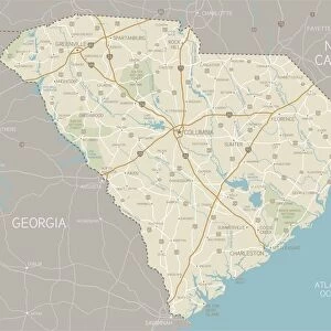
Photo Mug : Map of South Carolina 1893


![]()
Home Decor From Fine Art Storehouse
Map of South Carolina 1893
New Pocket Atlas / Rand, McNally & Co -1893
Unleash your creativity and transform your space into a visual masterpiece!
THEPALMER
Media ID 18356709
Large Photo Mug (15 oz)
Add a touch of history to your daily routine with our Media Storehouse Photo Mug featuring a vintage Map of South Carolina from 1893, taken from the New Pocket Atlas by THEPALMER and published by Rand, McNally & Co. This high-quality mug showcases intricate details of the map, transporting you back in time with every sip. Perfect for tea or coffee, this mug makes a unique and thoughtful gift for history enthusiasts, travelers, or anyone who appreciates the beauty of old maps. Embrace the past and start your day with a piece of history in your hands.
Elevate your coffee or tea experience with our premium white ceramic mug. Its wide, comfortable handle makes drinking easy, and you can rely on it to be both microwave and dishwasher safe. Sold in single units, preview may show both sides of the same mug so you can see how the picture wraps around.
Elevate your coffee or tea experience with our premium white ceramic mug. Its wide, comfortable handle makes drinking easy, and you can rely on it to be both microwave and dishwasher safe. Sold in single units, preview may show both sides of the same mug so you can see how the picture wraps around.
These are individually made so all sizes are approximate
FEATURES IN THESE COLLECTIONS
> Fine Art Storehouse
> Map
> Historical Maps
> Maps and Charts
> Related Images
EDITORS COMMENTS
In this print titled "Map of South Carolina 1893" we are transported back in time to the late 19th century, where cartography was an art form and exploration was at its peak. Created by THEPALMER, this exquisite piece showcases a vintage map from the New Pocket Atlas published by Rand, McNally & Co in 1893. The map itself is a testament to the meticulous craftsmanship of that era. Every intricate detail has been carefully etched onto paper, capturing the essence of South Carolina during a transformative period in its history. From the winding rivers and sprawling coastlines to the vibrant cities and charming towns, this map offers us a glimpse into what life may have been like over a century ago. As we study this historical artifact, we can't help but marvel at how much has changed since then. The boundaries have shifted, new roads have been built, and modern advancements have transformed both urban landscapes and rural communities alike. Yet amidst all these changes, there remains an undeniable sense of nostalgia for simpler times when maps were cherished possessions used for navigation or simply as works of art. "The Map of South Carolina 1893" serves as a reminder that our past shapes our present and future. It invites us to explore not only the physical geography but also delve into stories untold - tales of discovery, settlement, growth, and resilience that continue to shape South Carolina's identity today.
MADE IN THE USA
Safe Shipping with 30 Day Money Back Guarantee
FREE PERSONALISATION*
We are proud to offer a range of customisation features including Personalised Captions, Color Filters and Picture Zoom Tools
SECURE PAYMENTS
We happily accept a wide range of payment options so you can pay for the things you need in the way that is most convenient for you
* Options may vary by product and licensing agreement. Zoomed Pictures can be adjusted in the Basket.