Photo Mug > Maps and Charts > Africa
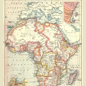
Photo Mug : Map of Africa 1900


![]()
Home Decor From Fine Art Storehouse
Map of Africa 1900
Meyers hand-Atlas Leipzig und Wien Verlag des Bibliographischen Instituts 1900
Unleash your creativity and transform your space into a visual masterpiece!
THEPALMER
Media ID 18356595
Large Photo Mug (15 oz)
"Bring a piece of historical artistry to your daily routine with our Media Storehouse Photo Mugs, featuring the captivating "Map of Africa 1900" by THEPALMER from Fine Art Storehouse. This intricately detailed map, originally published in the Meyers Hand-Atlas Leipzig und Wien Verlag des Bibliographischen Instituts 1900, is now transformed into a functional and stylish mug. Perfect for sipping your favorite beverage while exploring the rich history of Africa, each mug is printed with high-quality, vibrant colors to ensure the artwork remains true to the original. Add this unique and thoughtful gift to your collection or as a conversation starter for your kitchen or office. Embrace the beauty of the past, one sip at a time."
Elevate your coffee or tea experience with our premium white ceramic mug. Its wide, comfortable handle makes drinking easy, and you can rely on it to be both microwave and dishwasher safe. Sold in single units, preview may show both sides of the same mug so you can see how the picture wraps around.
Elevate your coffee or tea experience with our premium white ceramic mug. Its wide, comfortable handle makes drinking easy, and you can rely on it to be both microwave and dishwasher safe. Sold in single units, preview may show both sides of the same mug so you can see how the picture wraps around.
These are individually made so all sizes are approximate
FEATURES IN THESE COLLECTIONS
> Fine Art Storehouse
> Map
> Historical Maps
EDITORS COMMENTS
In this print titled "Map of Africa 1900". THEPALMER takes us on a journey back in time to the turn of the century. The map, sourced from Meyers hand-Atlas Leipzig und Wien Verlag des Bibliographischen Instituts 1900, offers a fascinating glimpse into the African continent as it was known over a hundred years ago. The intricate details and delicate lines etched onto this vintage map evoke a sense of exploration and discovery. As we study its contours, we are transported to an era when cartography was both artistry and science, meticulously crafted by skilled hands. Africa's vastness is beautifully depicted here; from the Sahara Desert stretching across North Africa to the lush rainforests that dominate Central Africa. We can trace ancient trade routes along the Nile River and marvel at the mighty Victoria Falls cascading down Southern Africa. This historical document not only serves as a visual representation but also sparks curiosity about how borders have shifted, nations have emerged, and cultures have evolved since then. It invites us to reflect on our shared human history while appreciating the diversity that defines this magnificent continent. "The Map of Africa 1900" is more than just an artwork; it is a window into another time—a reminder of how far we've come and how much there still remains for us to explore.
MADE IN THE USA
Safe Shipping with 30 Day Money Back Guarantee
FREE PERSONALISATION*
We are proud to offer a range of customisation features including Personalised Captions, Color Filters and Picture Zoom Tools
SECURE PAYMENTS
We happily accept a wide range of payment options so you can pay for the things you need in the way that is most convenient for you
* Options may vary by product and licensing agreement. Zoomed Pictures can be adjusted in the Basket.