Photo Mug > Animals > Mammals > Muridae > Plains Mouse
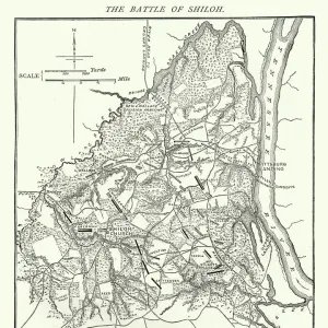
Photo Mug : Antique Map of the Siege of Quebec - 18th Century


![]()
Home Decor From Fine Art Storehouse
Antique Map of the Siege of Quebec - 18th Century
Vintage map of the Siege of Quebec in Quebec, Canada. Vintage etching circa late 19th century
Unleash your creativity and transform your space into a visual masterpiece!
powerofforever
Media ID 15149735
© This content is subject to copyright
Territory Battle Of The Plains Of Abraham French And Indian War Siege Of Quebec
Large Photo Mug (15 oz)
Step back in time with our Media Storehouse Photo Mug featuring an exquisite antique map of the Siege of Quebec from the Fine Art Storehouse collection. This vintage map, dating back to the late 19th century, showcases an intricate etching of the historic siege that took place in Quebec, Canada during the 18th century. Perfect for history enthusiasts or as a unique gift, this mug not only holds your favorite beverage but also tells a story with every sip. Embrace the past and add a touch of history to your daily routine.
Elevate your coffee or tea experience with our premium white ceramic mug. Its wide, comfortable handle makes drinking easy, and you can rely on it to be both microwave and dishwasher safe. Sold in single units, preview may show both sides of the same mug so you can see how the picture wraps around.
Elevate your coffee or tea experience with our premium white ceramic mug. Its wide, comfortable handle makes drinking easy, and you can rely on it to be both microwave and dishwasher safe. Sold in single units, preview may show both sides of the same mug so you can see how the picture wraps around.
These are individually made so all sizes are approximate
FEATURES IN THESE COLLECTIONS
> Fine Art Storehouse
> History
> Battles & Wars
> Historcal Battle Maps and Plans
> Fine Art Storehouse
> Map
> Historical Maps
> Animals
> Mammals
> Muridae
> Plains Mouse
> Historic
> Battles
> Related Images
> Maps and Charts
> Related Images
> North America
> Canada
> Maps
> North America
> Canada
> Related Images
EDITORS COMMENTS
This print takes us back in time to the 18th century, immersing us in a pivotal moment of history - the Siege of Quebec. The vintage map beautifully captures the intricate details of this significant event that unfolded in Quebec, Canada. As we gaze upon this antique etching, created during the late 19th century, we are transported to an era where territory and power were fiercely contested. The French and Indian War serves as the backdrop for this intense battle, which ultimately led to the Siege of Quebec. The map showcases key locations and strategic points that played a crucial role in shaping the outcome of this historic conflict. From its elegant design to its meticulous depiction of topography, every element on this print tells a story. One cannot help but be drawn into the narrative surrounding the Battle of Plains of Abraham - a defining moment within this siege. This clash between British and French forces forever altered North American history. With each glance at this remarkable artwork by powerofforever from Fine Art Storehouse, one can almost hear echoes from cannons firing and soldiers marching through time. As we admire this extraordinary piece, let us appreciate not only its aesthetic value but also its ability to transport us back centuries ago when nations clashed over land and ideals. It is through art like this that we gain insight into our past while cherishing our present-day peace and unity
MADE IN THE USA
Safe Shipping with 30 Day Money Back Guarantee
FREE PERSONALISATION*
We are proud to offer a range of customisation features including Personalised Captions, Color Filters and Picture Zoom Tools
SECURE PAYMENTS
We happily accept a wide range of payment options so you can pay for the things you need in the way that is most convenient for you
* Options may vary by product and licensing agreement. Zoomed Pictures can be adjusted in the Basket.