Photo Mug > Asia > Related Images
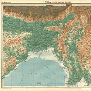
Photo Mug : Map of the Bay of Bengal, 1898 (colour litho)
")
")
![]()
Home Decor From Fine Art Finder
Map of the Bay of Bengal, 1898 (colour litho)
XCF291096 Map of the Bay of Bengal, 1898 (colour litho) by English School, (19th century); Private Collection; English, out of copyright
Media ID 12793567
© www.bridgemanimages.com
British Empire British Raj Burma Geographical Mapping Myanmar
Large Photo Mug (15 oz)
Add a touch of maritime history to your daily routine with our Media Storehouse Photo Mugs. Featuring an exquisite 1898 Map of the Bay of Bengal, this vibrant color lithograph by the English School is a stunning representation of the region's rich maritime past. This detailed map, out of copyright and sourced from Bridgeman Images through Fine Art Finder, is sure to make your mug stand out from the rest. Each mug is carefully crafted to preserve the intricate details of the image, allowing you to enjoy a piece of history with every sip. Perfect for tea or coffee lovers, this unique mug is a must-have for anyone with an appreciation for history and cartography.
Elevate your coffee or tea experience with our premium white ceramic mug. Its wide, comfortable handle makes drinking easy, and you can rely on it to be both microwave and dishwasher safe. Sold in single units, preview may show both sides of the same mug so you can see how the picture wraps around.
Elevate your coffee or tea experience with our premium white ceramic mug. Its wide, comfortable handle makes drinking easy, and you can rely on it to be both microwave and dishwasher safe. Sold in single units, preview may show both sides of the same mug so you can see how the picture wraps around.
These are individually made so all sizes are approximate
FEATURES IN THESE COLLECTIONS
> Fine Art Finder
> Schools
> English School
> Asia
> Related Images
EDITORS COMMENTS
This print showcases a remarkable piece of history, the "Map of the Bay of Bengal, 1898". Created by an anonymous English School artist in the 19th century, this colour lithograph offers a glimpse into the cartographic mastery and geographical knowledge prevalent during that era. The map, now part of a private collection, takes us back to a time when British influence extended across vast territories. The intricate details and vibrant hues bring to life the sprawling expanse encompassing Burma (now Myanmar) and India. Every contour is meticulously depicted, revealing coastlines, rivers, islands, and cities with utmost precision. This visual representation not only serves as an invaluable tool for navigation but also reflects the power dynamics within the British Empire at its height. As we explore this historic artifact further, it becomes evident that this map played an essential role in shaping colonial policies and trade routes throughout Asia. It symbolizes both exploration and exploitation as well as cultural exchange between nations. The mention of "British Raj" reminds us of how imperialism shaped these regions' destiny. Preserved through time by Fine Art Finder's dedication to preserving historical treasures like this one from their extensive collection sourced from various archives worldwide; this photograph print allows us to appreciate not only its aesthetic beauty but also its educational value. It invites us to delve into our past while acknowledging how geography has evolved over centuries.
MADE IN THE USA
Safe Shipping with 30 Day Money Back Guarantee
FREE PERSONALISATION*
We are proud to offer a range of customisation features including Personalised Captions, Color Filters and Picture Zoom Tools
SECURE PAYMENTS
We happily accept a wide range of payment options so you can pay for the things you need in the way that is most convenient for you
* Options may vary by product and licensing agreement. Zoomed Pictures can be adjusted in the Basket.