Photo Mug > Europe > France > Amiens
Photo Mug : Map of Artois (France) and Flanders (Belgium, Netherlands) (Engraving, 1717)
 and Flanders (Belgium, Netherlands) (Engraving, 1717)")
 and Flanders (Belgium, Netherlands) (Engraving, 1717)")
![]()
Home Decor from Fine Art Finder
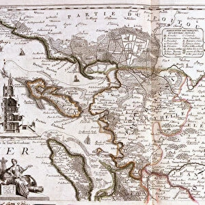
Map of Artois (France) and Flanders (Belgium, Netherlands) (Engraving, 1717)
LRI4711743 Map of Artois (France) and Flanders (Belgium, Netherlands) (Engraving, 1717) by Nolin, Jean-Baptiste (c.1657-1708); Private Collection; (add.info.: Map of the Count of Artois (Lower and Upper Picardy), with West Flanders and Gallicans and the generality of Amiens - Engraving from the atlas le theatre du monde, 1717, by Jean Baptiste Nolin (1686-1762) - Map of Artois (France) and Flanders (Belgium, Netherlands) - From " Le Theatre du Monde" 1717 by Jean-Baptiste Nolin); Luisa Ricciarini; French, out of copyright
Media ID 23717808
© Luisa Ricciarini / Bridgeman Images
Atlas Book Flanders Picardy Geographical Map
Large Photo Mug (15 oz)
Add a touch of history to your daily routine with our Media Storehouse Photo Mug featuring an exquisite engraving of the Map of Artois (France) and Flanders (Belgium, Netherlands) from 1717. This beautiful antique map, copyrighted by Luisa Ricciarini from Fine Art Finder, showcases intricate details of the region as depicted by Jean-Baptiste Nolin. Each mug holds your favorite beverage while transporting you back in time. Perfect for history enthusiasts or as a unique gift.
Elevate your coffee or tea experience with our premium white ceramic mug. Its wide, comfortable handle makes drinking easy, and you can rely on it to be both microwave and dishwasher safe. Sold in single units, preview may show both sides of the same mug so you can see how the picture wraps around.
Elevate your coffee or tea experience with our premium white ceramic mug. Its wide, comfortable handle makes drinking easy, and you can rely on it to be both microwave and dishwasher safe. Sold in single units, preview may show both sides of the same mug so you can see how the picture wraps around.
These are individually made so all sizes are approximate
FEATURES IN THESE COLLECTIONS
> Fine Art Finder
> Artists
> Jean-Baptiste Nolin
> Fine Art Finder
> Artists
> Unknown Artist
> Europe
> Belgium
> Related Images
> Europe
> Netherlands
> Maps
> Europe
> Netherlands
> Posters
> Europe
> Netherlands
> Related Images
EDITORS COMMENTS
This engraving, titled "Map of Artois (France) and Flanders (Belgium, Netherlands)" takes us back to the year 1717. Created by Jean-Baptiste Nolin, a renowned French cartographer of the time, this map showcases the intricate details and precision that were characteristic of his work. The map encompasses the Count of Artois in Lower and Upper Picardy, along with West Flanders and Gallicans. It is part of Nolin's famous atlas called "Le Theatre du Monde" which was published in 1717. This particular piece offers a glimpse into the geographical landscape during the 18th century. With its delicate engravings and meticulous labeling, this print serves as both an artistic masterpiece and a historical document. It provides valuable insights into the political boundaries, topography, and landmarks of these regions at that time. As we observe this enchanting artwork by Luisa Ricciarini from Fine Art Finder today, it reminds us of how maps have always been essential tools for exploration and understanding our world. They not only guide us through physical spaces but also offer glimpses into past civilizations. Whether you are fascinated by geography or simply appreciate fine artistry, this exquisite engraving transports you to an era long gone while showcasing the remarkable talent of Jean-Baptiste Nolin.
MADE IN THE USA
Safe Shipping with 30 Day Money Back Guarantee
FREE PERSONALISATION*
We are proud to offer a range of customisation features including Personalised Captions, Color Filters and Picture Zoom Tools
SECURE PAYMENTS
We happily accept a wide range of payment options so you can pay for the things you need in the way that is most convenient for you
* Options may vary by product and licensing agreement. Zoomed Pictures can be adjusted in the Cart.