Photo Mug > Arts > Artists > B > Benin Benin
Photo Mug : Map of Dahomey (colour litho)
")
")
![]()
Home Decor from Fine Art Finder
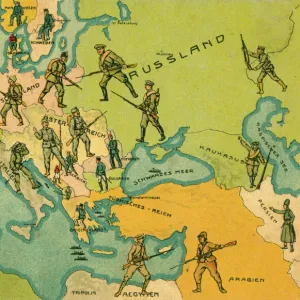
Map of Dahomey (colour litho)
2818321 Map of Dahomey (colour litho) by French School, (19th century); Private Collection; (add.info.: Map of Dahomey. Carte du Dahomey. Illustration for Le Petit Journal, 3 September 1892.); © Look and Learn
Media ID 23156298
© Look and Learn / Bridgeman Images
Benin Continent Dahomey Scramble For Africa West Africa
Large Photo Mug (15 oz)
Bring a piece of historical artistry into your daily routine with our Media Storehouse Photo Mug featuring the captivating Map of Dahomey by the French School from Fine Art Finder. This beautiful 19th-century color lithograph, showcasing the intricate details of the Dahomey Kingdom, transforms your mug into a unique and thought-provoking accessory. Perfect for tea or coffee, this high-quality mug is a must-have for history enthusiasts and collectors alike. Add a touch of culture and art to your morning brew with the Map of Dahomey Photo Mug from Media Storehouse.
Elevate your coffee or tea experience with our premium white ceramic mug. Its wide, comfortable handle makes drinking easy, and you can rely on it to be both microwave and dishwasher safe. Sold in single units, preview may show both sides of the same mug so you can see how the picture wraps around.
Elevate your coffee or tea experience with our premium white ceramic mug. Its wide, comfortable handle makes drinking easy, and you can rely on it to be both microwave and dishwasher safe. Sold in single units, preview may show both sides of the same mug so you can see how the picture wraps around.
These are individually made so all sizes are approximate
FEATURES IN THESE COLLECTIONS
> Fine Art Finder
> Artists
> French School
> Fine Art Finder
> Artists
> Henri (after) Meyer
> Africa
> Benin
> Related Images
> Arts
> Artists
> B
> Benin Benin
> Maps and Charts
> Related Images
EDITORS COMMENTS
This vibrant and detailed lithograph takes us back to the 19th century, offering a glimpse into the colonial era of Dahomey, now known as Benin. The Map of Dahomey showcases the intricate geography of this West African country, highlighting its significance during the scramble for Africa. Created by an anonymous French School artist, this print was originally featured in Le Petit Journal on September 3rd, 1892. It serves as a testament to France's imperial ambitions and their influence over their overseas territories. The colours used in this litho are strikingly vivid, bringing life to every contour and boundary line. As we explore this map, we can't help but marvel at how it encapsulates both historical accuracy and artistic flair. Dahomey itself holds great cultural importance within Africa. Its rich heritage is intertwined with French culture due to its status as one of France's overseas departments and territories during that time period. As we gaze upon this remarkable piece from Bridgeman Images' private collection, we are reminded not only of the power dynamics that shaped Africa's history but also of the beauty found within cartography. This map invites us to reflect on our world's complex past while appreciating the artistry behind portraying it visually.
MADE IN THE USA
Safe Shipping with 30 Day Money Back Guarantee
FREE PERSONALISATION*
We are proud to offer a range of customisation features including Personalised Captions, Color Filters and Picture Zoom Tools
SECURE PAYMENTS
We happily accept a wide range of payment options so you can pay for the things you need in the way that is most convenient for you
* Options may vary by product and licensing agreement. Zoomed Pictures can be adjusted in the Cart.