Photo Mug > Maps and Charts > World
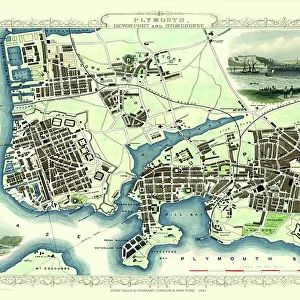
Photo Mug : Map: Plymouth Sound (colour litho)
")
")
![]()
Home Decor From Fine Art Finder
Map: Plymouth Sound (colour litho)
6004713 Map: Plymouth Sound (colour litho) by English School, (19th century); Private Collection; (add.info.: Plymouth Sound. Illustration for A Gazetteer of the World or Dictionary of Geographical Knowledge (A Fullarton, 1858).); © Look and Learn; English, out of copyright
Media ID 23284962
© Look and Learn / Bridgeman Images
Large Photo Mug (15 oz)
Bring the beauty of Plymouth Sound into your daily routine with our Media Storehouse Photo Mugs. Featuring an exquisite 19th century color lithograph map of Plymouth Sound by Bridgeman Images from Fine Art Finder, these mugs are a perfect blend of art and functionality. This stunning representation of the English coastline, taken from a private collection, adds a touch of elegance and charm to your morning coffee or evening tea. Each mug is expertly crafted for durability and holds the vibrant colors of the map image in high definition. Make every sip a journey to the shores of Plymouth Sound with our Media Storehouse Photo Mugs.
Elevate your coffee or tea experience with our premium white ceramic mug. Its wide, comfortable handle makes drinking easy, and you can rely on it to be both microwave and dishwasher safe. Sold in single units, preview may show both sides of the same mug so you can see how the picture wraps around.
Elevate your coffee or tea experience with our premium white ceramic mug. Its wide, comfortable handle makes drinking easy, and you can rely on it to be both microwave and dishwasher safe. Sold in single units, preview may show both sides of the same mug so you can see how the picture wraps around.
These are individually made so all sizes are approximate
FEATURES IN THESE COLLECTIONS
> Fine Art Finder
> Artists
> English School
> Maps and Charts
> Early Maps
> Maps and Charts
> Related Images
> Maps and Charts
> World
EDITORS COMMENTS
This print showcases a vibrant and detailed map of Plymouth Sound, created by an English School artist in the 19th century. The map, rendered through the technique of colour lithography, is part of a private collection and offers a fascinating glimpse into historical geography. Plymouth Sound, depicted in this artwork, holds immense historical significance as it served as a crucial naval base during the mid-19th century. This particular illustration was originally featured in "A Gazetteer of the World or Dictionary of Geographical Knowledge" published by A Fullarton in 1858. The intricate details on this map allow us to explore the waterways surrounding Plymouth with great precision. It provides valuable insights into navigation routes used during that era and highlights key landmarks within the area. As we delve into this piece, we are transported back to Victorian times when exploration and discovery were at their peak. The colours employed in this lithograph bring life to every corner of Plymouth Sound's coastline and evoke a sense of adventure. Preserved for generations to come, this image from Fine Art Finder allows us to appreciate not only its aesthetic beauty but also its historical importance. It serves as a reminder that maps hold stories waiting to be discovered; they offer windows into our past while igniting curiosity about what lies beyond their borders.
MADE IN THE USA
Safe Shipping with 30 Day Money Back Guarantee
FREE PERSONALISATION*
We are proud to offer a range of customisation features including Personalised Captions, Color Filters and Picture Zoom Tools
SECURE PAYMENTS
We happily accept a wide range of payment options so you can pay for the things you need in the way that is most convenient for you
* Options may vary by product and licensing agreement. Zoomed Pictures can be adjusted in the Basket.