Canvas Print > Maps and Charts > World
Canvas Print : Map: Plymouth Sound (colour litho)
")
")
![]()
Canvas Prints From Fine Art Finder
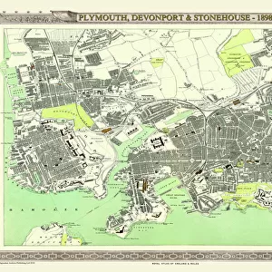
Map: Plymouth Sound (colour litho)
6004713 Map: Plymouth Sound (colour litho) by English School, (19th century); Private Collection; (add.info.: Plymouth Sound. Illustration for A Gazetteer of the World or Dictionary of Geographical Knowledge (A Fullarton, 1858).); © Look and Learn; English, out of copyright
Media ID 23284962
© Look and Learn / Bridgeman Images
30"x20" (76x51cm) Canvas Print
Discover the rich maritime history of Plymouth Sound with our stunning Canvas Print from Media Storehouse. Featuring the captivating color lithograph by Bridgeman Images from Fine Art Finder, this Map: Plymouth Sound (6004713) by the English School (19th century) adds a touch of history and character to any room. Printed on high-quality canvas with vibrant colors and impressive detail, this artwork is a must-have for nautical enthusiasts and those who appreciate the beauty of historical maps. Bring the past to life in your home or office with this beautiful and intriguing piece.
Delivered stretched and ready to hang our premium quality canvas prints are made from a polyester/cotton blend canvas and stretched over a 1.25" (32mm) kiln dried knot free wood stretcher bar. Packaged in a plastic bag and secured to a cardboard insert for safe transit.
Canvas Prints add colour, depth and texture to any space. Professionally Stretched Canvas over a hidden Wooden Box Frame and Ready to Hang
Estimated Product Size is 50.8cm x 76.2cm (20" x 30")
These are individually made so all sizes are approximate
Artwork printed orientated as per the preview above, with portrait (vertical) orientation to match the source image.
FEATURES IN THESE COLLECTIONS
> Maps and Charts
> Early Maps
> Maps and Charts
> Related Images
> Maps and Charts
> World
> Fine Art Finder
> Artists
> English School
EDITORS COMMENTS
This print showcases a vibrant and detailed map of Plymouth Sound, created by an English School artist in the 19th century. The map, rendered through the technique of colour lithography, is part of a private collection and offers a fascinating glimpse into historical geography. Plymouth Sound, depicted in this artwork, holds immense historical significance as it served as a crucial naval base during the mid-19th century. This particular illustration was originally featured in "A Gazetteer of the World or Dictionary of Geographical Knowledge" published by A Fullarton in 1858. The intricate details on this map allow us to explore the waterways surrounding Plymouth with great precision. It provides valuable insights into navigation routes used during that era and highlights key landmarks within the area. As we delve into this piece, we are transported back to Victorian times when exploration and discovery were at their peak. The colours employed in this lithograph bring life to every corner of Plymouth Sound's coastline and evoke a sense of adventure. Preserved for generations to come, this image from Fine Art Finder allows us to appreciate not only its aesthetic beauty but also its historical importance. It serves as a reminder that maps hold stories waiting to be discovered; they offer windows into our past while igniting curiosity about what lies beyond their borders.
MADE IN THE USA
Safe Shipping with 30 Day Money Back Guarantee
FREE PERSONALISATION*
We are proud to offer a range of customisation features including Personalised Captions, Color Filters and Picture Zoom Tools
SECURE PAYMENTS
We happily accept a wide range of payment options so you can pay for the things you need in the way that is most convenient for you
* Options may vary by product and licensing agreement. Zoomed Pictures can be adjusted in the Basket.