Photo Mug > Arts > Artists > C > William Clark
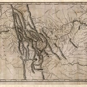
Photo Mug : Map Of The Lewis And Clark American Expedition, 1804-1806, Published 1814 In History Of The Expedition Under The Command Of Captains Lewis And Clark Etc By Nicholas Biddle And Edited By Paul Allen


![]()
Home Decor From Design Pics
Map Of The Lewis And Clark American Expedition, 1804-1806, Published 1814 In History Of The Expedition Under The Command Of Captains Lewis And Clark Etc By Nicholas Biddle And Edited By Paul Allen
Design Pics offers Distinctively Different Imagery representing over 1,500 contributors
Media ID 18195706
© Ken Welsh / Design Pics
Captain Clark Command Expedition Exploration Explore First Lewis Northwest Route States United William Captains Meriwether
Photo Mug (11 oz)
Step back in time with our Media Storehouse Photo Mug featuring the iconic Map of the Lewis and Clark American Expedition, 1804-1806. Published in 1814 in "History of the Expedition Under the Command of Captains Lewis and Clark, etc." by Nicholas Biddle and edited by Paul Allen, this historic map is now available in a convenient and stylish mug form. Perfect for coffee or tea, this high-quality mug showcases the intricate details of the map, making it a unique and thoughtful gift for history enthusiasts or avid collectors. Embrace the past with every sip.
A personalized photo mug blends sentimentality with functionality, making an ideal gift for cherished loved ones, close friends, or valued colleagues. Preview may show both sides of the same mug.
Elevate your coffee or tea experience with our premium white ceramic mug. Its wide, comfortable handle makes drinking easy, and you can rely on it to be both microwave and dishwasher safe. Sold in single units, preview may show both sides of the same mug so you can see how the picture wraps around.
Mug Size is 8cm high x 9.5cm diameter (3.1" x 3.7")
These are individually made so all sizes are approximate
FEATURES IN THESE COLLECTIONS
> Arts
> Artists
> C
> William Clark
EDITORS COMMENTS
This print showcases a historical treasure, the "Map Of The Lewis And Clark American Expedition, 1804-1806". Published in 1814 as part of the renowned "History of the Expedition under the Command of Captains Lewis and Clark" this map offers a fascinating glimpse into one of America's most significant explorations. The map traces the route taken by Meriwether Lewis and William Clark during their groundbreaking expedition across the United States. With meticulous detail, it highlights their remarkable journey through uncharted territories, providing valuable insights into early American exploration. As we delve into this visual masterpiece captured by Ken Welsh, we are transported back to a time when vast regions of North America remained unknown. It serves as a testament to human curiosity and determination to explore new frontiers. Every line on this map represents an adventure waiting to unfold; every landmark symbolizes triumph over adversity. It reminds us that these brave captains embarked on an arduous quest for knowledge, encountering diverse landscapes and indigenous cultures along their path. With its rich historical significance and intricate cartographic details, this print is not only visually stunning but also serves as a reminder of our nation's pioneering spirit. As we gaze upon it, let us appreciate the courage and resilience displayed by those who paved the way for future generations' discoveries in America's northwest region.
MADE IN THE USA
Safe Shipping with 30 Day Money Back Guarantee
FREE PERSONALISATION*
We are proud to offer a range of customisation features including Personalised Captions, Color Filters and Picture Zoom Tools
SECURE PAYMENTS
We happily accept a wide range of payment options so you can pay for the things you need in the way that is most convenient for you
* Options may vary by product and licensing agreement. Zoomed Pictures can be adjusted in the Basket.