Home > North America > United States of America > Missouri > Columbia
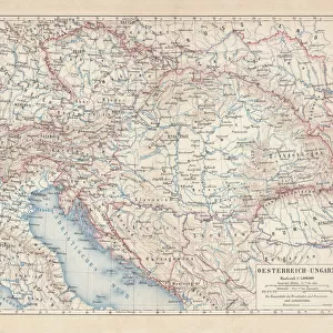
MAP: LEWIS AND CLARK, 1814. A map tracing the progress of the 1804 Lewis and Clark

![]()
Wall Art and Photo Gifts from Granger
MAP: LEWIS AND CLARK, 1814. A map tracing the progress of the 1804 Lewis and Clark
MAP: LEWIS AND CLARK, 1814.
A map tracing the progress of the 1804 Lewis and Clark Expedition from St. Charles, Missouri to the mouth of the Columbia River. Original map drawn by William Clark and copied by Samuel Lewis, 1814
Granger holds millions of images spanning more than 25,000 years of world history, from before the Stone Age to the dawn of the Space Age
Media ID 13642984
1804 1814 Clark Expedition Exploration Lewis Lewis And Clark Meriwether North America Rocky Mountain Samuel William
FEATURES IN THESE COLLECTIONS
> Arts
> Artists
> C
> William Clark
> Arts
> Landscape paintings
> Waterfall and river artworks
> River artworks
> North America
> United States of America
> Missouri
> Columbia
EDITORS COMMENTS
This print showcases a historical treasure - the 1814 map tracing the remarkable journey of the Lewis and Clark Expedition. Embarking in 1804 from St. Charles, Missouri, Meriwether Lewis and William Clark set out on an audacious exploration that would forever shape North America's understanding of its vast western frontier. The sepia-toned map, originally drawn by William Clark himself and copied meticulously by Samuel Lewis, offers a visual testament to their awe-inspiring progress. It vividly depicts their arduous trek through uncharted territories, across rugged Rocky Mountains, and along untamed rivers until they reached the mouth of the Columbia River. As we gaze upon this historic artifact, we are transported back in time to an era when intrepid explorers ventured into unknown lands with unwavering determination. The intricate details on this map serve as a testament to their meticulous documentation of geographical features encountered during their expedition. This print is not just a mere depiction; it is a gateway to reliving one of history's most significant journeys. It invites us to marvel at the bravery and resilience displayed by these trailblazers who expanded our knowledge of the American West. Granger Art on Demand has masterfully captured this piece from The Granger Collection for all history enthusiasts to cherish. Let this extraordinary image transport you back in time as you explore the triumphs and challenges faced by Lewis and Clark during their legendary expedition.
MADE IN THE USA
Safe Shipping with 30 Day Money Back Guarantee
FREE PERSONALISATION*
We are proud to offer a range of customisation features including Personalised Captions, Color Filters and Picture Zoom Tools
SECURE PAYMENTS
We happily accept a wide range of payment options so you can pay for the things you need in the way that is most convenient for you
* Options may vary by product and licensing agreement. Zoomed Pictures can be adjusted in the Cart.