Mouse Mat > Animals > Insects > Hemiptera > Hall Scale
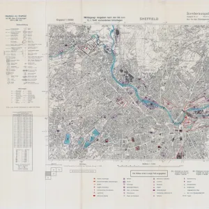
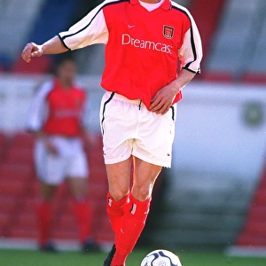
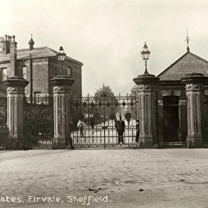
Mouse Mat : Sheffield Workhouse, Fir Vale, later Northern General Hospital on Ordnance Survey map, 1905

![]()
Home Decor From Sheffield City Archives
Sheffield Workhouse, Fir Vale, later Northern General Hospital on Ordnance Survey map, 1905
Scale 25 inches : 1 mile.Sheet 288.16.Also shows Longley Hall, Goddard Hall and Bolsover Cottages
Sheffield City Archives and Local Studies Library has an unrivalled collection of images of Sheffield, England
Media ID 14049021
© Sheffield City Council
Barnsley Bolsover General Hall Hospital Hospitals Houses Housing Lane Maps Northern Road Sheffield Vale Cottages Goddard Herries Longley Piper Workhouses
Mouse Pad
Standard Size Mouse Pad 7.75" x 9..25". High density Neoprene w linen surface. Easy to clean, stain resistant finish. Rounded corners.
Archive quality photographic print in a durable wipe clean mouse mat with non slip backing. Works with all computer mice
Estimated Product Size is 20.2cm x 23.7cm (8" x 9.3")
These are individually made so all sizes are approximate
Artwork printed orientated as per the preview above, with portrait (vertical) orientation to match the source image.
FEATURES IN THESE COLLECTIONS
> Animals
> Insects
> Hemiptera
> Hall Scale
> Maps and Charts
> Related Images
EDITORS COMMENTS
This print from Sheffield City Archives showcases the historical Sheffield Workhouse, later transformed into the renowned Northern General Hospital. The image is a snapshot of an Ordnance Survey map dating back to 1905, providing a fascinating glimpse into the city's past. The scale of 25 inches to 1 mile allows us to examine intricate details on Sheet 288.16. Alongside the prominent workhouse-turned-hospital, other notable landmarks are also depicted in this comprehensive map. Longley Hall, Goddard Hall, and Bolsover Cottages make their appearance as well, adding depth and context to the surrounding area. As we delve into this visual treasure trove of information, it becomes evident that Fir Vale and Herries Road were integral parts of Sheffield's history. The presence of these hospitals within Sheffield Union Workhouses underscores their significance in providing care for those in need during that era. While exploring further, one cannot help but notice additional points of interest such as housing developments along Piper Lane and Barnsley Road. These structures serve as reminders of how communities evolved over time and adapted to meet growing demands. It is important to note that this print should not be used for commercial purposes; instead, its value lies in preserving our heritage and understanding our city's rich history through maps like these held by Sheffield City Archives.
MADE IN THE USA
Safe Shipping with 30 Day Money Back Guarantee
FREE PERSONALISATION*
We are proud to offer a range of customisation features including Personalised Captions, Color Filters and Picture Zoom Tools
FREE COLORIZATION SERVICE
You can choose advanced AI Colorization for this picture at no extra charge!
SECURE PAYMENTS
We happily accept a wide range of payment options so you can pay for the things you need in the way that is most convenient for you
* Options may vary by product and licensing agreement. Zoomed Pictures can be adjusted in the Basket.