Mouse Mat > North America > United States of America > New York > New York > Maps
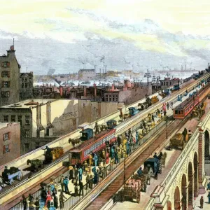
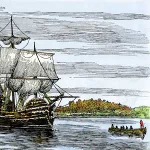
Mouse Mat : Manhattan in 1767


![]()
Home Decor From North Wind
Manhattan in 1767
Ratzer map of New York City, 1767.
Hand-colored woodcut reproduction of an 18th-century illustration
North Wind Picture Archives brings history to life with stock images and hand-colored illustrations
Media ID 5882549
© North Wind Picture Archives
1700s 1760s 18th Century Chart Colonial Colonist Colony English English Colony Harbor Manhattan New York New York City 1767
Mouse Pad
Standard Size Mouse Pad 7.75" x 9..25". High density Neoprene w linen surface. Easy to clean, stain resistant finish. Rounded corners.
Archive quality photographic print in a durable wipe clean mouse mat with non slip backing. Works with all computer mice
Estimated Image Size (if not cropped) is 23.7cm x 18.7cm (9.3" x 7.4")
Estimated Product Size is 23.7cm x 20.2cm (9.3" x 8")
These are individually made so all sizes are approximate
Artwork printed orientated as per the preview above, with landscape (horizontal) orientation to match the source image.
FEATURES IN THESE COLLECTIONS
> Historic
> Colonial America illustrations
> 18th century America
> Historic
> Colonial America illustrations
> Colonial America
> Historic
> Colonial America illustrations
> Historic
> Colonial history
> Colonial art and artists
> North America
> United States of America
> New York
> New York
> Manhattan
> Related Images
> North America
> United States of America
> New York
> New York
> Maps
> North America
> United States of America
> New York
> Related Images
> North Wind Picture Archives
> Maps
> North Wind Picture Archives
> New York City
EDITORS COMMENTS
This print takes us back in time to the bustling streets of Manhattan in 1767. The Ratzer map of New York City, meticulously hand-colored and reproduced from an 18th-century illustration, offers a glimpse into the rich heritage and traditional charm of this iconic American city. As we gaze upon this vintage masterpiece, we are transported to a bygone era when New York was still a colony under English rule. The detailed chart showcases the layout of Manhattan with its narrow streets and colonial architecture, providing valuable insight into the city's early development. The image captures the essence of life during that period - ships dotting the harbor as they unload goods from distant lands, colonists going about their daily routines, and English influence permeating every corner. It serves as a visual reminder of how far this great metropolis has come since those humble beginnings. With its vibrant colors and intricate details, this woodcut reproduction is not just a work of art but also an invaluable historical artifact. It allows us to appreciate the foundations on which modern-day New York City stands today – reminding us that beneath its towering skyscrapers lies a deep-rooted history that shaped it into one of the most influential cities in North America. Whether you are an art enthusiast or history buff, this print will transport you back in time to experience firsthand what life was like in Manhattan over two centuries ago.
MADE IN THE USA
Safe Shipping with 30 Day Money Back Guarantee
FREE PERSONALISATION*
We are proud to offer a range of customisation features including Personalised Captions, Color Filters and Picture Zoom Tools
SECURE PAYMENTS
We happily accept a wide range of payment options so you can pay for the things you need in the way that is most convenient for you
* Options may vary by product and licensing agreement. Zoomed Pictures can be adjusted in the Basket.