Mouse Mat > Arts > Street art graffiti > Portraits > Fine art
Mouse Mat : Ottoman Empire / Map 16C


![]()
Home Decor from Mary Evans Picture Library
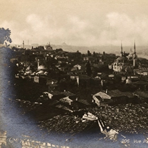
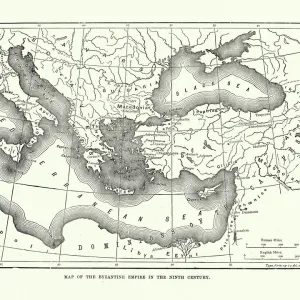
Ottoman Empire / Map 16C
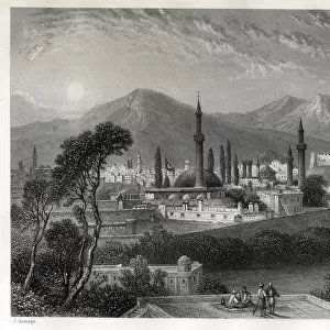
Istanbul in the 16th century, after the Turks captured it. The map is entitled Byzantium, now Constantinople
Mary Evans Picture Library makes available wonderful images created for people to enjoy over the centuries
Media ID 617518
© Mary Evans Picture Library 2015 - https://copyrighthub.org/s0/hub1/creation/maryevans/MaryEvansPictureID/10084001
Captured Constantinople Emperors Medallion Turks Twelve Ottoman
Mouse Pad
Standard Size Mouse Pad 7.75" x 9..25". High density Neoprene w linen surface. Easy to clean, stain resistant finish. Rounded corners.
Archive quality photographic print in a durable wipe clean mouse mat with non slip backing. Works with all computer mice
Estimated Image Size (if not cropped) is 23.7cm x 17.7cm (9.3" x 7")
Estimated Product Size is 23.7cm x 20.2cm (9.3" x 8")
These are individually made so all sizes are approximate
Artwork printed orientated as per the preview above, with landscape (horizontal) orientation to match the source image.
FEATURES IN THESE COLLECTIONS
> Arts
> Street art graffiti
> Portraits
> Fine art
> Asia
> Turkey
> Related Images
> Maps and Charts
> Early Maps
> Maps and Charts
> Related Images
EDITORS COMMENTS
This exquisite 16th-century map, titled "Byzantium, now Constantinople," offers a captivating glimpse into the historical transformation of Istanbul during the Ottoman Empire. The map, produced during the height of Ottoman power, illustrates the city as it appeared after the Turks' successful conquest in 1453. The Ottoman Empire, under the reign of Sultan Mehmed II, had captured the once-mighty Byzantine capital, marking the end of the Byzantine Empire and the beginning of a new era. The map's intricate details and decorative elements reflect the grandeur and sophistication of the Ottoman court. The central focus of the map is Istanbul, with its strategic location at the crossroads of Europe and Asia. The Bosphorus Strait, which divides Europe and Asia, is depicted as a winding ribbon of water, connecting the Sea of Marmara to the Black Sea. The map also highlights key landmarks, including the Golden Horn, the Hagia Sophia, and the Bosphorus Bridge. Surrounding the map, a decorative medallion showcases the portraits of twelve emperors, both Byzantine and Ottoman, who ruled over the city throughout history. The Ottoman emperors are depicted in traditional Turkish attire, while the Byzantine emperors are shown in imperial robes and crowns. This visual juxtaposition underscores the historical significance of the Ottoman conquest and the passage of power from one empire to another. The map's intricate details and historical importance make it a valuable resource for scholars, historians, and anyone interested in the rich history of Istanbul and the Ottoman Empire. This beautiful print is a testament to the enduring allure of the past and the power of cartography to transport us back in time.
MADE IN THE USA
Safe Shipping with 30 Day Money Back Guarantee
FREE PERSONALISATION*
We are proud to offer a range of customisation features including Personalised Captions, Color Filters and Picture Zoom Tools
SECURE PAYMENTS
We happily accept a wide range of payment options so you can pay for the things you need in the way that is most convenient for you
* Options may vary by product and licensing agreement. Zoomed Pictures can be adjusted in the Cart.