Mouse Mat > Arts > Artists > S > John Speed
Mouse Mat : Old Map of The Province of Ulster 1611 by John Speed


Home Decor From MapSeeker
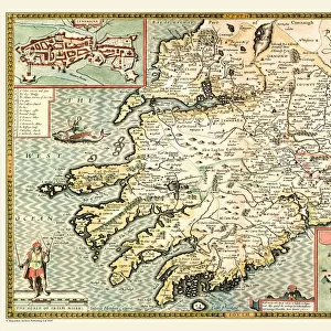
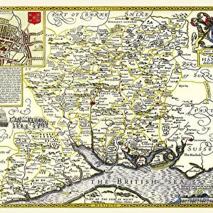
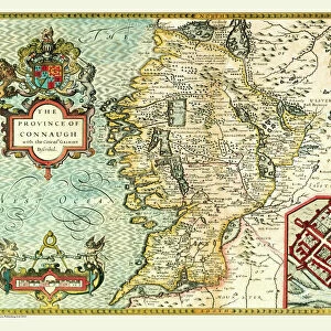
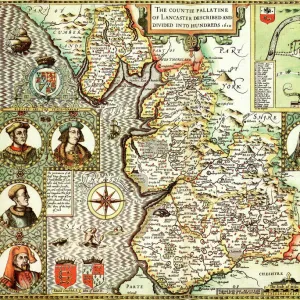
Old Map of The Province of Ulster 1611 by John Speed
A facimile of John Speeds historical map of the Province of Ulster originally published for the " Theatre of the Empire of Great Britain", an atlas to accompany " a history of Great Britain"
Welcome to the Mapseeker Image library and enter an historic gateway to one of the largest on-line collections of Historic Maps, Nostalgic Views, Vista's and Panorama's from a World gone by.
Media ID 20347874
© Mapseeker Publishing Ltd
Historic Map John Speed Map Speed Map Speede Map Ulster
Mouse Pad
Standard Size Mouse Pad 7.75" x 9..25". High density Neoprene w linen surface. Easy to clean, stain resistant finish. Rounded corners.
Archive quality photographic print in a durable wipe clean mouse mat with non slip backing. Works with all computer mice
Estimated Image Size (if not cropped) is 23.7cm x 16.5cm (9.3" x 6.5")
Estimated Product Size is 23.7cm x 20.2cm (9.3" x 8")
These are individually made so all sizes are approximate
Artwork printed orientated as per the preview above, with landscape (horizontal) orientation to match the source image.
FEATURES IN THESE COLLECTIONS
> MapSeeker
> Maps from the British Isles
> Ireland and Provinces PORTFOLIO
> Arts
> Artists
> S
> John Speed
> Europe
> Republic of Ireland
> Maps
> Maps and Charts
> British Empire Maps
> Maps and Charts
> Early Maps
EDITORS COMMENTS
This print showcases the "Old Map of The Province of Ulster 1611" by John Speed, a renowned cartographer of his time. Originally published for the "Theatre of the Empire of Great Britain" an atlas accompanying "a history of Great Britain" this facsimile offers a glimpse into the rich historical landscape of Ireland's provinces. With intricate details and exquisite artistry, this map provides a visual journey through the Irish provinces, specifically focusing on Ulster. Its significance lies in its portrayal as it stood in 1611, offering valuable insights into the region's past. As we explore this old map, we are transported back to a time when borders were defined differently and kingdoms held sway over territories. The divisions within Ulster become apparent as each province is meticulously outlined with precision and accuracy. John Speed's expertise shines through in every stroke and contour, capturing not only geographical features but also cultural nuances that shaped Ulster during that era. This historic document serves as a testament to his dedication to cartography and his commitment to preserving knowledge for future generations. Whether you have ancestral ties to Ulster or simply appreciate historical maps, this print allows you to immerse yourself in Ireland's past. It invites us all to marvel at how our world has evolved while reminding us that beneath modern landscapes lie layers upon layers of history waiting to be discovered.
MADE IN THE USA
Safe Shipping with 30 Day Money Back Guarantee
FREE PERSONALISATION*
We are proud to offer a range of customisation features including Personalised Captions, Color Filters and Picture Zoom Tools
SECURE PAYMENTS
We happily accept a wide range of payment options so you can pay for the things you need in the way that is most convenient for you
* Options may vary by product and licensing agreement. Zoomed Pictures can be adjusted in the Basket.