Home > Arts > Artists > S > John Speed
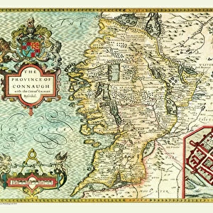
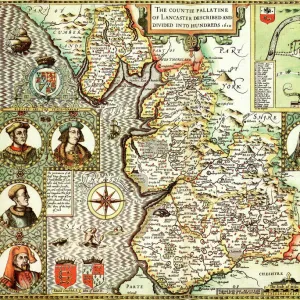
Old Map of The Province of Leinster, Ireland 1611 by John Speed

![]()
Wall Art and Photo Gifts from MapSeeker
Old Map of The Province of Leinster, Ireland 1611 by John Speed
A facimile of John Speeds historical map of the Province of Leinster originally published for the " Theatre of the Empire of Great Britain", an atlas to accompany " a history of Great Britain"
Welcome to the Mapseeker Image library and enter an historic gateway to one of the largest on-line collections of Historic Maps, Nostalgic Views, Vista's and Panorama's from a World gone by.
Media ID 20347733
© Mapseeker Publishing Ltd
Historic Map John Speed Map Speed Map Speede Map Leinster
FEATURES IN THESE COLLECTIONS
> Arts
> Artists
> S
> John Speed
> Europe
> Republic of Ireland
> Maps
> Maps and Charts
> British Empire Maps
> Maps and Charts
> Early Maps
> Maps and Charts
> Related Images
> MapSeeker
> Maps from the British Isles
> Ireland and Provinces PORTFOLIO
EDITORS COMMENTS
This print showcases an exquisite piece of history - the "Old Map of The Province of Leinster, Ireland 1611" by John Speed. As a faithful facsimile of Speed's original map, which was published for the renowned "Theatre of the Empire of Great Britain" this artifact offers a glimpse into the rich heritage and intricate geography of Leinster province. Crafted to accompany a comprehensive account titled "A History of Great Britain" this map serves as both an informative tool and a work of art. Its meticulous details depict not only the boundaries and towns within Leinster but also provide insights into the broader context in which it existed. With its delicate lines and elegant calligraphy, this old map transports us back to a time when cartography was both science and art. It invites us to explore the historical significance that lies within each contour, river, or settlement depicted on its surface. Whether you are an avid historian or simply fascinated by maps, this print is sure to captivate your imagination. Let it transport you through time as you unravel centuries-old stories hidden within its carefully drawn borders. Discover how John Speed's masterful craftsmanship has preserved a slice of Irish history for generations to come with this remarkable depiction of Leinster province.
MADE IN THE USA
Safe Shipping with 30 Day Money Back Guarantee
FREE PERSONALISATION*
We are proud to offer a range of customisation features including Personalised Captions, Color Filters and Picture Zoom Tools
SECURE PAYMENTS
We happily accept a wide range of payment options so you can pay for the things you need in the way that is most convenient for you
* Options may vary by product and licensing agreement. Zoomed Pictures can be adjusted in the Cart.