Mouse Mat > Europe > United Kingdom > England > London > Boroughs > City of London
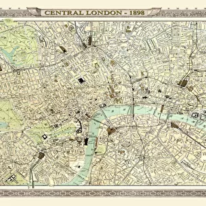
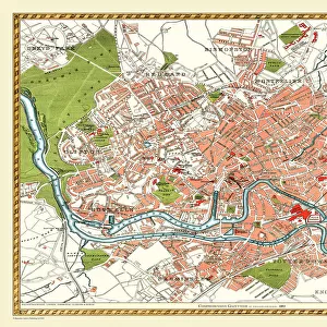
Mouse Mat : Old Map of London 1898 from the Royal Atlas by Bartholomew


![]()
Home Decor from MapSeeker
Old Map of London 1898 from the Royal Atlas by Bartholomew
A fine very detailed plan of the City of London remastered from an original contained within " The Royal Atlas of England and Wales" ; edited by J.G. Bartholomew, published by George Newnes, Limited, London
Welcome to the Mapseeker Image library and enter an historic gateway to one of the largest on-line collections of Historic Maps, Nostalgic Views, Vista's and Panorama's from a World gone by.
Media ID 20347600
Bartholomew Bartholomew Map Historic Map London Map Map Of London Old Town Plan Royal Atlas Royal Atlas Map London City
Mouse Pad
Standard Size Mouse Pad 7.75" x 9..25". High density Neoprene w linen surface. Easy to clean, stain resistant finish. Rounded corners.
Archive quality photographic print in a durable wipe clean mouse mat with non slip backing. Works with all computer mice
Estimated Image Size (if not cropped) is 23.7cm x 16.5cm (9.3" x 6.5")
Estimated Product Size is 23.7cm x 20.2cm (9.3" x 8")
These are individually made so all sizes are approximate
Artwork printed orientated as per the preview above, with landscape (horizontal) orientation to match the source image.
FEATURES IN THESE COLLECTIONS
> MapSeeker
> British Town And City Plans
> English & Welsh PORTFOLIO
> Arts
> Photorealistic artworks
> Detailed art pieces
> Masterful detailing in art
> Europe
> United Kingdom
> England
> London
> Boroughs
> City of London
> Europe
> United Kingdom
> England
> London
> Royalty
> Europe
> United Kingdom
> England
> Maps
> Europe
> United Kingdom
> Wales
> Maps
> Europe
> United Kingdom
> Wales
> Posters
> Maps and Charts
> Related Images
> Maps and Charts
> Wales
EDITORS COMMENTS
Step back in time with this exquisite print of the 'Old Map of London 1898' from the renowned Royal Atlas by Bartholomew. Immerse yourself in the rich history and intricate details captured within this fine plan of the City of London. Remastered from an original contained within 'The Royal Atlas of England and Wales, ' edited by J. G. Bartholomew, and published by George Newnes, Limited, London; this map offers a fascinating glimpse into the past. Transport yourself to a bygone era as you explore the streets, landmarks, and neighborhoods that shaped one of the world's greatest cities. Every corner is meticulously depicted on this historic map - from bustling markets to majestic palaces, winding alleys to grand boulevards. The level of detail will captivate both history enthusiasts and lovers of cartography alike. This old town plan serves as a testament to London's enduring legacy while providing invaluable insights into its urban development over time. Whether you're tracing your family roots or simply appreciating the artistry behind vintage maps, this print is sure to be a cherished addition to any collection
MADE IN THE USA
Safe Shipping with 30 Day Money Back Guarantee
FREE PERSONALISATION*
We are proud to offer a range of customisation features including Personalised Captions, Color Filters and Picture Zoom Tools
SECURE PAYMENTS
We happily accept a wide range of payment options so you can pay for the things you need in the way that is most convenient for you
* Options may vary by product and licensing agreement. Zoomed Pictures can be adjusted in the Cart.