Fraud Blocker Skip to main content

London Map Collection

"Unveiling the Timeless Charm of London

Background imageLondon Map Collection: Old Street Map of Bethnal Green and Hackney 1908

Old Street Map of Bethnal Green and Hackney 1908
Detailed colour Street Plan of London from 1908 covering the area around Bethnal Green and Hackney. The image has been remastered from Bartholomews Handy Atlas of London and Suburbs 1908

Background imageLondon Map Collection: Old Street Map of The Isle of Dogs and River Thames at Greenwich 1908

Old Street Map of The Isle of Dogs and River Thames at Greenwich 1908
Detailed colour Street Plan of London from 1908 covering the area around The Isle of Dogs and The River Thames at Greenwich.The image has been remastered from Bartholomews Handy Atlas of London

Background imageLondon Map Collection: Old Map of London 1851 by John Tallis

Old Map of London 1851 by John Tallis
Commemorating the Great Exhibition of Industry of All Nations 1851, this magnificent plan of London, re-created and art worked directly from the antique original

Background imageLondon Map Collection: Old Street Map of Kensington and Notting Hill 1908

Old Street Map of Kensington and Notting Hill 1908
Detailed colour Street Plan of London from 1908 covering the area around Kensington and Notting Hill. The image has been remastered from Bartholomews Handy Atlas of London and Suburbs 1908

Background imageLondon Map Collection: Old Street Map of The Strand, West End and River Thames 1908

Old Street Map of The Strand, West End and River Thames 1908
Detailed colour Street Plan of London from 1908 covering the area around The Strand, The West End and the River Thames.The image has been remastered from Bartholomews Handy Atlas of London

Background imageLondon Map Collection: Old Street Map of Hamstead, Holloway and Islington 1908

Old Street Map of Hamstead, Holloway and Islington 1908
Detailed colour Street Plan of London from 1908 covering the area around Hamstead, Holloway and Islington. The image has been remastered from Bartholomews Handy Atlas of London and Suburbs 1908

Background imageLondon Map Collection: London Westminster (City Breaks)

London Westminster (City Breaks)
Simon Goggin

Background imageLondon Map Collection: London Battersea (City Breaks)

London Battersea (City Breaks)
Simon Goggin

Background imageLondon Map Collection: London City (City Breaks)

London City (City Breaks)
Simon Goggin

Background imageLondon Map Collection: London City (City Breaks)

London City (City Breaks)
Simon Goggin

Background imageLondon Map Collection: London Battersea (City Breaks)

London Battersea (City Breaks)
Simon Goggin

Background imageLondon Map Collection: London Westminster (City Breaks)

London Westminster (City Breaks)
Simon Goggin

Background imageLondon Map Collection: Old Street Map of Chelsea, Putney and River Thames 1908

Old Street Map of Chelsea, Putney and River Thames 1908
Detailed colour Street Plan of London from 1908 covering the area around Chelsea, Putney and the River Thames. The image has been remastered from Bartholomews Handy Atlas of London and Suburbs 1908

Background imageLondon Map Collection: Old Street Map of Oxford Street, Holborn and Euston Road 1908

Old Street Map of Oxford Street, Holborn and Euston Road 1908
Detailed colour Street Plan of London from 1908 covering the area around Oxford Street, Holborn and Euston Road.The image has been remastered from Bartholomews Handy Atlas of London and Suburbs 1908

Background imageLondon Map Collection: Old Street Map of Woolwich and Thames Docklands 1908

Old Street Map of Woolwich and Thames Docklands 1908
Detailed colour Street Plan of London from 1908 covering the area around Woolwich and the Thames Docklands.The image has been remastered from Bartholomews Handy Atlas of London and Suburbs 1908

Background imageLondon Map Collection: Old Map of Central London 1898 from the Royal Atlas by Bartholomew

Old Map of Central London 1898 from the Royal Atlas by Bartholomew
A fine very detailed plan of Central London from 1898 remastered from an original contained within " The Royal Atlas of England and Wales" ; edited by J.G

Background imageLondon Map Collection: Old Map of London 1898 from the Royal Atlas by Bartholomew

Old Map of London 1898 from the Royal Atlas by Bartholomew
A fine very detailed plan of the City of London remastered from an original contained within " The Royal Atlas of England and Wales" ; edited by J.G

Background imageLondon Map Collection: Old Map of the Environs of London 1836 by Thomas Moule

Old Map of the Environs of London 1836 by Thomas Moule
This is a fine decorative reproduction Map of The Environs of London from the First Edition series of Thomas Moule Maps, originally Published in 1836


All Professionally Made to Order for Quick Shipping

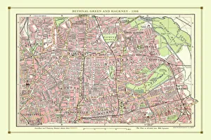
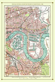
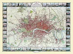
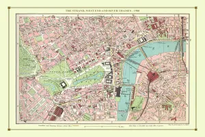
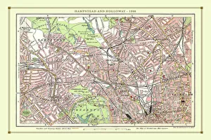
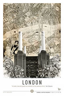
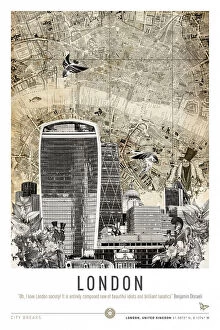
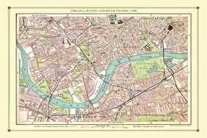
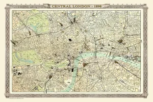
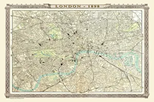
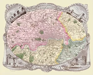
"Unveiling the Timeless Charm of London: A Journey through Vintage Maps" Step back in time and immerse yourself in the rich history of London with these captivating old street maps. Delve into the intricate details of a bygone era as you explore the city's hidden gems, starting with an enchanting glimpse of Bethnal Green and Hackney from 1908. Follow the winding paths along The Isle of Dogs and let your imagination wander to Greenwich on the banks of River Thames. Continue your voyage through time as you navigate Hamstead, Holloway, and Islington using a meticulously crafted map from 1908. Trace each street corner with curiosity, envisioning how life unfolded amidst these bustling neighborhoods over a century ago. Marvel at The Strand's grandeur in West End while tracing its path alongside River Thames on another exquisite map from 1908. For those seeking even older treasures, John Tallis' remarkable 1851 depiction offers an extraordinary window into London's past. Lose yourself in its intricacies and imagine strolling through Chelsea or Putney along the serene banks of River Thames. Embark on a visual journey down Oxford Street, Holborn, and Euston Road using yet another beautifully preserved map from 1908. Let your mind wander to bustling crowds traversing these iconic streets during Edwardian times. Experience Woolwich's maritime heritage come alive as you explore its vibrant docklands on a stunningly detailed map also dating back to 1908. Transport yourself to an era when trade flourished along this historic stretch of River Thames. Discover Central London anew with Bartholomew's Royal Atlas representation from 1898 - every nook and cranny brought vividly to life within this masterpiece. Traverse Kensington and Notting Hill through their charming streetscapes that have stood witness to countless stories throughout centuries gone by.