Home > Europe > United Kingdom > England > London > Towns > Notting Hill
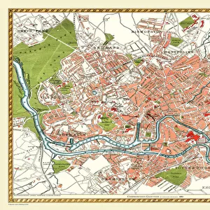
Old Street Map of Kensington and Notting Hill 1908

![]()
Wall Art and Photo Gifts from MapSeeker
Old Street Map of Kensington and Notting Hill 1908
Detailed colour Street Plan of London from 1908 covering the area around Kensington and Notting Hill. The image has been remastered from Bartholomews Handy Atlas of London and Suburbs 1908
Welcome to the Mapseeker Image library and enter an historic gateway to one of the largest on-line collections of Historic Maps, Nostalgic Views, Vista's and Panorama's from a World gone by.
Media ID 20347501
© Mapseeker Publishing Ltd, Collins Bartholomew Ltd
London Map London Street Plan Map Of Central London Map Of London Old London Street Map Old Map Of London Central Street Map Of London Street Plan Kensington Notting Hill
FEATURES IN THESE COLLECTIONS
> Arts
> Photorealistic artworks
> Detailed art pieces
> Masterful detailing in art
> Europe
> United Kingdom
> England
> London
> Boroughs
> Kensington and Chelsea
> Europe
> United Kingdom
> England
> London
> Towns
> Kensington
> Europe
> United Kingdom
> England
> London
> Towns
> Notting Hill
> Maps and Charts
> Related Images
> MapSeeker
> British Town And City Plans
> English & Welsh PORTFOLIO
EDITORS COMMENTS
This print takes us back in time to the bustling streets of Kensington and Notting Hill in 1908. A meticulously detailed street map, carefully remastered from Bartholomews Handy Atlas of London and Suburbs, allows us to explore the rich history of this iconic area. As we gaze upon this old street map, a sense of nostalgia washes over us. The vibrant colors bring life to the intricate network of roads that once guided horse-drawn carriages and pedestrians alike. Every corner is marked with precision, showcasing the architectural marvels that have stood the test of time. The image transports us to an era where gas lamps illuminated these streets at night, casting a warm glow on the elegant Victorian townhouses and charming cobblestone lanes. It invites us to imagine strolling through these historic neighborhoods, soaking in their unique charm and character. John Bartholomew's expertise shines through as he captures every minute detail with utmost accuracy. This piece serves not only as a visual delight but also as a valuable historical document that preserves the essence of early 20th-century London. Whether you are an avid historian or simply captivated by vintage maps, this stunning print offers a window into London's past like no other. It is a testament to our ever-evolving cityscape while reminding us of its enduring beauty throughout centuries.
MADE IN THE USA
Safe Shipping with 30 Day Money Back Guarantee
FREE PERSONALISATION*
We are proud to offer a range of customisation features including Personalised Captions, Color Filters and Picture Zoom Tools
SECURE PAYMENTS
We happily accept a wide range of payment options so you can pay for the things you need in the way that is most convenient for you
* Options may vary by product and licensing agreement. Zoomed Pictures can be adjusted in the Cart.