Mouse Mat > Arts > Artists > O > Abraham Ortelius
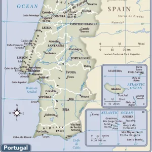
Mouse Mat : Theatrum Orbis Terrarum by Abraham Ortelius, Antwerp, 1574. Map of the Iberian Peninsula


![]()
Home Decor From Heritage Images
Theatrum Orbis Terrarum by Abraham Ortelius, Antwerp, 1574. Map of the Iberian Peninsula
Heritage Images features heritage image collections
Media ID 15196344
© Mithra - Index / Heritage-Images
Abraham Abraham Ortelius Antwerp Barcelona Catalonia Iberian Library Of Catalonia Maps Orbis Ortelius Peninsula Portugal Spain Catalonia Barcelone Spain Catalonia Barcelonés Terrarum Theatrum Santiago Ortega
Mouse Pad
Standard Size Mouse Pad 7.75" x 9..25". High density Neoprene w linen surface. Easy to clean, stain resistant finish. Rounded corners.
Archive quality photographic print in a durable wipe clean mouse mat with non slip backing. Works with all computer mice
Estimated Image Size (if not cropped) is 23.7cm x 19.1cm (9.3" x 7.5")
Estimated Product Size is 23.7cm x 20.2cm (9.3" x 8")
These are individually made so all sizes are approximate
Artwork printed orientated as per the preview above, with landscape (horizontal) orientation to match the source image.
FEATURES IN THESE COLLECTIONS
> Arts
> Artists
> O
> Abraham Ortelius
> Europe
> Portugal
> Related Images
> Maps and Charts
> Abraham Ortelius
> Maps and Charts
> Related Images
> Maps and Charts
> Spain
EDITORS COMMENTS
This print showcases a remarkable piece of cartographic history, "Theatrum Orbis Terrarum" by Abraham Ortelius, printed in Antwerp in 1574. The map specifically focuses on the Iberian Peninsula, providing an intriguing glimpse into the geographical knowledge and artistic skills of the 16th century. Abraham Ortelius, a renowned Flemish cartographer, meticulously crafted this masterpiece that now resides in the Library of Catalonia. The vibrant colors beautifully highlight the intricate details of this horizontal map. From Barcelona to Santiago de Compostela, every city and town is delicately marked with precision. As we explore this ancient artifact through Santiago Ortega's lens, we are transported back in time to an era when maps were not only navigational tools but also works of art. This particular map captures Spain and Portugal during their golden age as maritime powers. The rich historical significance embedded within this image evokes curiosity about how people perceived their world centuries ago. It serves as a reminder of our ever-evolving understanding of geography and how it shapes our collective identity. Preserved for generations to come, this photograph allows us to appreciate both the craftsmanship behind Ortelius' work and its enduring cultural value. Let us marvel at this snapshot from history that connects us with past explorations while igniting our own sense of wanderlust and discovery.
MADE IN THE USA
Safe Shipping with 30 Day Money Back Guarantee
FREE PERSONALISATION*
We are proud to offer a range of customisation features including Personalised Captions, Color Filters and Picture Zoom Tools
SECURE PAYMENTS
We happily accept a wide range of payment options so you can pay for the things you need in the way that is most convenient for you
* Options may vary by product and licensing agreement. Zoomed Pictures can be adjusted in the Basket.