Mouse Mat > Europe > France > Canton > Nord
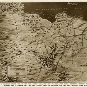
Mouse Mat : Grande Kabylie et Djurdjura; Afrique du nord, 1914. Creator: Unknown


![]()
Home Decor from Heritage Images
Grande Kabylie et Djurdjura; Afrique du nord, 1914. Creator: Unknown
Grande Kabylie et Djurdjura; Afrique du nord, 1914. From "Grande Geographie Bong Illustree", 1914
Heritage Images features heritage image collections
Media ID 36294723
© The Print Collector/Heritage Images
Algeria Algerian Atlas Mountains Cartography Map Making Mapmaking Mediterranean Sea Mountain Range North Africa North African
Mouse Pad
Standard Size Mouse Pad 7.75" x 9..25". High density Neoprene w linen surface. Easy to clean, stain resistant finish. Rounded corners.
Archive quality photographic print in a durable wipe clean mouse mat with non slip backing. Works with all computer mice
Estimated Image Size (if not cropped) is 23.7cm x 13.5cm (9.3" x 5.3")
Estimated Product Size is 23.7cm x 20.2cm (9.3" x 8")
These are individually made so all sizes are approximate
Artwork printed orientated as per the preview above, with landscape (horizontal) orientation to match the source image.
FEATURES IN THESE COLLECTIONS
> Africa
> Algeria
> Related Images
> Europe
> France
> Canton
> Nord
> Maps and Charts
> Related Images
Grande Kabylie et Djurdjura; Afrique du Nord, 1914
EDITORS COMMENTS
is an intriguing print showcasing a portion of North Africa during the early 20th century. The image, created by an unknown cartographer, was originally published in "Grande Geographie Bong Illustree" in 1914. The print depicts a section of Algeria, specifically the Kabylie region and the Djurdjura mountain range. The Kabylie region, located in the northeastern part of Algeria, is bordered by the city of Bordj Bou Arréridj. The Djurdjura mountain range, a part of the Atlas Mountains, is situated in the northwest of Kabylie and stretches along the Mediterranean coast. The print's engraving technique results in a detailed and precise representation of the geographical features in the region. The Mediterranean Sea is visible on the right side of the print, with the coastline of Algeria clearly marked. The mountain range is depicted with a sense of grandeur, its peaks reaching towards the sky. This print offers a glimpse into the cartography of the early 1900s and the European exploration and mapping of North Africa. The French influence is evident in the labeling of the region as "Afrique du Nord," reflecting the French colonial rule during that time. The print serves as a historical artifact, providing valuable information about the geography of the region during a significant period in African history. Its black and white aesthetic adds to its timeless appeal, making it a fascinating addition to any collection of historical maps or African studies. Despite the unknown creator, this print remains an essential piece of cartographic history, offering insights into the exploration and mapping of North Africa during the early 20th century. Its intricate details and historical significance make it a must-have for collectors, historians, and anyone interested in the history of Africa and cartography.
MADE IN THE USA
Safe Shipping with 30 Day Money Back Guarantee
FREE PERSONALISATION*
We are proud to offer a range of customisation features including Personalised Captions, Color Filters and Picture Zoom Tools
SECURE PAYMENTS
We happily accept a wide range of payment options so you can pay for the things you need in the way that is most convenient for you
* Options may vary by product and licensing agreement. Zoomed Pictures can be adjusted in the Cart.