Mouse Mat > Animals > Mammals > Dogs (Domestic) > Working > Newfoundland
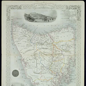
Mouse Mat : Nova Scotia and Newfoundland, from a Series of World Maps published by John Tallis & Co


![]()
Home Decor From Fine Art Finder
Nova Scotia and Newfoundland, from a Series of World Maps published by John Tallis & Co
STC190610 Nova Scotia and Newfoundland, from a Series of World Maps published by John Tallis & Co. New York & London, 1850s (engraving) by Rapkin, John (fl.1839-77); Private Collection; (add.info.: vignette illustrations by A. Fussell, engraved by J. Rogers; seals of Nova Scotia and Cape Breton, and Newfoundland; ); The Stapleton Collection; British, out of copyright
Media ID 22339974
© The Stapleton Collection / Bridgeman Images
Atlantic Ocean Halifax Lawrence Seal America Continent Canadians Gulf Of St
Mouse Pad
Standard Size Mouse Pad 7.75" x 9..25". High density Neoprene w linen surface. Easy to clean, stain resistant finish. Rounded corners.
Archive quality photographic print in a durable wipe clean mouse mat with non slip backing. Works with all computer mice
Estimated Image Size (if not cropped) is 23.7cm x 18.9cm (9.3" x 7.4")
Estimated Product Size is 23.7cm x 20.2cm (9.3" x 8")
These are individually made so all sizes are approximate
Artwork printed orientated as per the preview above, with landscape (horizontal) orientation to match the source image.
FEATURES IN THESE COLLECTIONS
> Fine Art Finder
> Artists
> John Rapkin
> Fine Art Finder
> Maps (celestial & Terrestrial)
> Animals
> Fishes
> A
> Atlantic Cod
> Animals
> Mammals
> Dogs (Domestic)
> Working
> Newfoundland
> Arts
> Artists
> O
> Oceanic Oceanic
> Arts
> Artists
> R
> John Rapkin
> Arts
> Artists
> R
> John Rogers
> Arts
> Artists
> T
> John Tallis
> Maps and Charts
> Related Images
> Maps and Charts
> World
> North America
> Canada
> Maps
EDITORS COMMENTS
This print showcases the stunning beauty of Nova Scotia and Newfoundland, two picturesque regions in Canada. Published by John Tallis & Co in the 1850s, this engraving by John Rapkin transports us back in time to a period when exploration and cartography were at their peak. The intricate details of this map are truly remarkable. Vignette illustrations by A. Fussell, expertly engraved by J. Rogers, adorn the borders of the map and add an artistic touch to the piece. The seals of Nova Scotia and Cape Breton, as well as Newfoundland, proudly represent these Canadian provinces. As we delve deeper into the image, we notice various elements that bring life to this historic depiction. A charming seal basks on a rocky outcrop while a loyal dog stands guard nearby – symbols of resilience and companionship found throughout these lands. The Gulf of St Lawrence stretches majestically across the map's expanse, reminding us of its vital role in maritime trade during that era. The cod fishery off Newfoundland is also prominently featured - an industry that has shaped both history and culture for generations. Halifax emerges as a prominent city within Nova Scotia with its bustling harbor serving as a gateway to North America for countless travelers over centuries past. This print not only serves as a testament to exceptional craftsmanship but also offers us glimpses into Canada's rich heritage and natural splendor. It invites viewers to explore these enchanting regions through time-honored artistry captured on paper
MADE IN THE USA
Safe Shipping with 30 Day Money Back Guarantee
FREE PERSONALISATION*
We are proud to offer a range of customisation features including Personalised Captions, Color Filters and Picture Zoom Tools
SECURE PAYMENTS
We happily accept a wide range of payment options so you can pay for the things you need in the way that is most convenient for you
* Options may vary by product and licensing agreement. Zoomed Pictures can be adjusted in the Basket.