Metal Print > Universal Images Group (UIG) > Art > Painting, Sculpture & Prints > Cartography
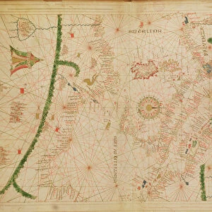
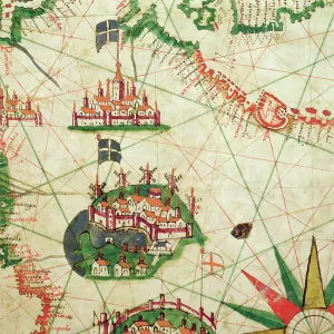
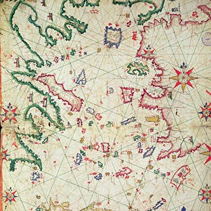
Metal Print : Mediterranean coast, from the Portolan Charts by Francesco Oliva, printed in Italy, 1611


![]()
Metal Prints From Universal Images Group (UIG)
Mediterranean coast, from the Portolan Charts by Francesco Oliva, printed in Italy, 1611
Cartography, 17th century. Mediterranean coast. From the Portolan Charts by Francesco Oliva, 1611
Universal Images Group (UIG) manages distribution for many leading specialist agencies worldwide
Media ID 9570437
© DEA / A. DAGLI ORTI
17th Century Camel Coastline Direction Guidance Mediterranean Sea Western Script Wind Rose
16"x20" (51x41cm) Metal Print
Step back in time with our exquisite Media Storehouse Metal Prints, featuring a captivating image from the Portolan Charts by Francesco Oliva, dated 1611. This magnificent piece, sourced from Universal Images Group (UIG), showcases the intricate detail of the Mediterranean coast as it appeared over 400 years ago. The vintage cartography comes alive in brilliant metallic tones, adding a touch of history and character to any space. Embrace the rich heritage of cartography and transport yourself to a bygone era with our stunning Metal Prints.
Made with durable metal and luxurious printing techniques, our metal photo prints go beyond traditional canvases, adding a cool, modern touch to your space. Wall mount on back. Eco-friendly 100% post-consumer recycled ChromaLuxe aluminum surface. The thickness of the print is 0.045". Featuring a Scratch-resistant surface and Rounded corners. Backing hangers are attached to the back of the print and float the print 1/2-inch off the wall when hung, the choice of hanger may vary depending on size and International orders will come with Float Mount hangers only. Finished with a brilliant white high gloss surface for unsurpassed detail and vibrance. Printed using Dye-Sublimation and for best care we recommend a non-ammonia glass cleaner, water, or isopropyl (rubbing) alcohol to prevent harming the print surface. We recommend using a clean, lint-free cloth to wipe off the print. The ultra-hard surface is scratch-resistant, waterproof and weatherproof. Avoid direct sunlight exposure.
Made with durable metal and luxurious printing techniques, metal prints bring images to life and add a modern touch to any space
Estimated Image Size (if not cropped) is 40.6cm x 50.8cm (16" x 20")
Estimated Product Size is 41.2cm x 51.4cm (16.2" x 20.2")
These are individually made so all sizes are approximate
Artwork printed orientated as per the preview above, with portrait (vertical) orientation to match the source image.
EDITORS COMMENTS
This stunning print captures the mesmerizing beauty of the Mediterranean coast, as depicted in Francesco Oliva's Portolan Charts from 1611. The intricate details and precision of this 17th-century map showcase the artistry and skill of cartography during that era. The image showcases a vast expanse of the Mediterranean Sea, stretching out towards the horizon with its deep blue hues. The coastline is meticulously outlined, highlighting various landmarks along its path. A wind rose elegantly adorns one corner, symbolizing direction and guidance for travelers navigating these waters. Intriguingly, a solitary camel gracefully stands on the shore, adding an unexpected touch to this historical depiction. Its presence hints at ancient trade routes and travel across these lands centuries ago. This horizontal print beautifully combines illustration and painting techniques to create a visual masterpiece that transports viewers back in time. With no people present in the scene, it allows us to focus solely on nature's grandeur and appreciate the immense history associated with this region. Whether you are fascinated by physical geography or simply captivated by art and craft from centuries past, this print offers a captivating glimpse into both worlds. It serves as a reminder of our connection to history while igniting wanderlust for those who dream of exploring these enchanting shores firsthand.
MADE IN THE USA
Safe Shipping with 30 Day Money Back Guarantee
FREE PERSONALISATION*
We are proud to offer a range of customisation features including Personalised Captions, Color Filters and Picture Zoom Tools
SECURE PAYMENTS
We happily accept a wide range of payment options so you can pay for the things you need in the way that is most convenient for you
* Options may vary by product and licensing agreement. Zoomed Pictures can be adjusted in the Basket.