Metal Print > Animals > Fishes > S > Smelt
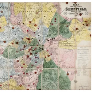
Metal Print : A map of the township of Dore, by W. and J. Fairbank, c. 1810-1820


![]()
Metal Prints From Sheffield City Archives
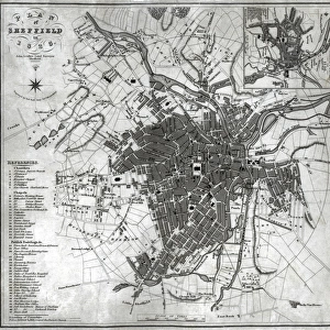
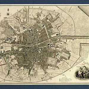
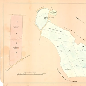
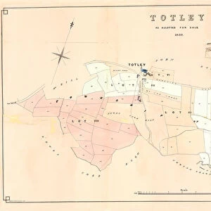
A map of the township of Dore, by W. and J. Fairbank, c. 1810-1820
No scale stated.
Shows Wilmer Edge, Reeve Edge, Burbage Rocks, Sheep hill, Hound Kirk Bage, Stony Ridge, Brawn Side, Strawberry Lee, Hall Field, White Lowe, Hound Kirk Hill, paper mill, smelting mill, Upper Mill, Totley, Nether Mill, River Sheaf, Bradway Mill, Dore, Oxen Green, Cupola, Round Seats, Hall Greave, Cliffe Side, Robin Hood Dyke, Rush Leys, Upper Causey Head, Nether Causey Head, Limb Dyke, Stand Hills, Barber Fields, Dore Moor Side, Ox Stone, Dore Gate Road. Dore Commons and Ancient inclosures indicated; also proposed new Turnpike road from Abbey Lane to Totley shown.
Original at Sheffield Libraries: arc01849
Sheffield City Archives and Local Studies Library has an unrivalled collection of images of Sheffield, England
Media ID 14086222
© Sheffield City Council
Derbyshire Sheffield Yorkshire Dore
16"x20" (51x41cm) Metal Print
Discover the rich history of Dore Township with our stunning Metal Print of the 1810-1820 map by W. and J. Fairbank, now available at Media Storehouse. This intricately detailed map showcases the layout of Dore, featuring notable landmarks such as Wilmer Edge, Reeve Edge, Burbage Rocks, Sheep Hill, Hound Kirk Bage, Stony Ridge, Brawn Side, Strawberry Lee, Hall Field, White Lowe, and Hound Kirk Hill. Each Metal Print is meticulously crafted, bringing the historical charm of this Sheffield City Archives map to life with vibrant colors and a sleek, modern design. Order yours today and add a touch of history to your home or office decor.
Made with durable metal and luxurious printing techniques, our metal photo prints go beyond traditional canvases, adding a cool, modern touch to your space. Wall mount on back. Eco-friendly 100% post-consumer recycled ChromaLuxe aluminum surface. The thickness of the print is 0.045". Featuring a Scratch-resistant surface and Rounded corners. Backing hangers are attached to the back of the print and float the print 1/2-inch off the wall when hung, the choice of hanger may vary depending on size and International orders will come with Float Mount hangers only. Finished with a brilliant white high gloss surface for unsurpassed detail and vibrance. Printed using Dye-Sublimation and for best care we recommend a non-ammonia glass cleaner, water, or isopropyl (rubbing) alcohol to prevent harming the print surface. We recommend using a clean, lint-free cloth to wipe off the print. The ultra-hard surface is scratch-resistant, waterproof and weatherproof. Avoid direct sunlight exposure.
Made with durable metal and luxurious printing techniques, metal prints bring images to life and add a modern touch to any space
Estimated Image Size (if not cropped) is 50.8cm x 40.6cm (20" x 16")
Estimated Product Size is 51.4cm x 41.2cm (20.2" x 16.2")
These are individually made so all sizes are approximate
Artwork printed orientated as per the preview above, with landscape (horizontal) orientation to match the source image.
FEATURES IN THESE COLLECTIONS
> Animals
> Fishes
> S
> Smelt
> Animals
> Insects
> Hemiptera
> Green Scale
> Animals
> Insects
> Hemiptera
> Hall Scale
> Animals
> Mammals
> Bovidae
> Ox
> Animals
> Mammals
> Bovidae
> Sheep
> Europe
> United Kingdom
> England
> Derbyshire
> Burbage
> Europe
> United Kingdom
> England
> Derbyshire
> Nether Moor
> Europe
> United Kingdom
> England
> Derbyshire
> New Mills
> Europe
> United Kingdom
> England
> Derbyshire
> Related Images
> Europe
> United Kingdom
> England
> Derbyshire
> Robin Hood
> Sheffield City Archives
> Maps and Plans
> Maps of Derbyshire
> Sheffield City Archives
> Maps and Plans
> Maps of Sheffield
EDITORS COMMENTS
This print showcases a historical map of the township of Dore, created by W. and J. Fairbank around 1810-1820. Although no scale is stated, this intricate map offers a detailed depiction of the area's landmarks and features. The map highlights various notable locations within Dore, such as Wilmer Edge, Reeve Edge, Burbage Rocks, Sheep hill, Hound Kirk Bage, Stony Ridge, Brawn Side, Strawberry Lee, Hall Field, White Lowe, Hound Kirk Hill. It also includes significant industrial sites like the paper mill and smelting mill. The presence of Upper Mill and Nether Mill along with the River Sheaf indicates the importance of water-powered industries in this region during that era. Additionally showcased are Bradway Mill and Oxen Green. Fascinatingly enough, this historic document goes beyond geographical details to include cultural aspects as well. The inclusion of Robin Hood Dyke suggests a connection to local folklore while Dore Commons and Ancient enclosures indicate land usage patterns at that time. Furthermore, the proposed new Turnpike road from Abbey Lane to Totley is marked on this map - an intriguing glimpse into future plans for transportation infrastructure development in the area. Preserved at Sheffield Libraries: arc01849), this print serves as a valuable resource for researchers interested in exploring the rich history of Dore in Derbyshire within Sheffield City Archives collection
MADE IN THE USA
Safe Shipping with 30 Day Money Back Guarantee
FREE PERSONALISATION*
We are proud to offer a range of customisation features including Personalised Captions, Color Filters and Picture Zoom Tools
SECURE PAYMENTS
We happily accept a wide range of payment options so you can pay for the things you need in the way that is most convenient for you
* Options may vary by product and licensing agreement. Zoomed Pictures can be adjusted in the Basket.
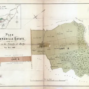
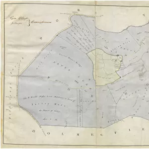

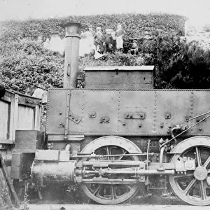
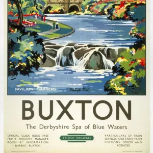
![Map of Woodthorpe Hall Farm [Holmesfield] in the parish of Dronfield, County of Derby, 1736](/sq/716/map-woodthorpe-hall-farm-holmesfield-parish-18987347.jpg.webp)