Metal Print : 16th Century Galleon

![]()
Metal Prints From Science Photo Library
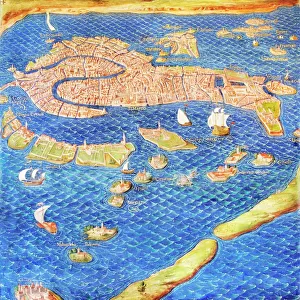
16th Century Galleon
16th century galleon in the Gulf of Porto. Detail from a map of Corsica in the Gallery of Maps in the Vatican Museum. These maps were commissioned between 1578 and 1580 to show the regions of Italy and territories of the church. They are based on the work of Ignazio Danti, a 16th century Italian priest, mathematician, astronomer and cosmographer, and are an important record of 16th century geography
Science Photo Library features Science and Medical images including photos and illustrations
Media ID 6319795
© Sheila Terry
1500s 16th Century Corsica Gallery Of Maps Ignazio Danti Italy Mapping Maps Nautical Sciences Sixteenth Century Galleon Sea Faring
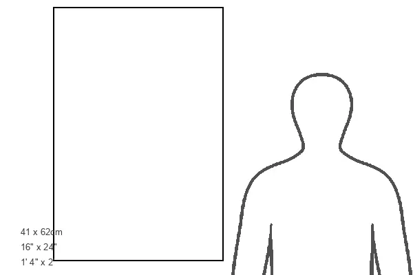
16"x24" (61x41cm) Metal Print
Bring history to life with our Media Storehouse Metal Prints featuring this stunning 16th century galleon image from Science Photo Library. Captured from a map of Corsica in the Vatican Museum, these intricately detailed galleons sailed the Gulf of Porto during an era of exploration and discovery. Our high-quality metal prints showcase vibrant colors and sharp details, ensuring your historical masterpiece becomes a captivating centerpiece in any room. Preserve this piece of history and add a touch of elegance to your home or office décor.
Made with durable metal and luxurious printing techniques, our metal photo prints go beyond traditional canvases, adding a cool, modern touch to your space. Wall mount on back. Eco-friendly 100% post-consumer recycled ChromaLuxe aluminum surface. The thickness of the print is 0.045". Featuring a Scratch-resistant surface and Rounded corners. Backing hangers are attached to the back of the print and float the print 1/2-inch off the wall when hung, the choice of hanger may vary depending on size and International orders will come with Float Mount hangers only. Finished with a brilliant white high gloss surface for unsurpassed detail and vibrance. Printed using Dye-Sublimation and for best care we recommend a non-ammonia glass cleaner, water, or isopropyl (rubbing) alcohol to prevent harming the print surface. We recommend using a clean, lint-free cloth to wipe off the print. The ultra-hard surface is scratch-resistant, waterproof and weatherproof. Avoid direct sunlight exposure.
Made with durable metal and luxurious printing techniques, metal prints bring images to life and add a modern touch to any space
Estimated Product Size is 41.2cm x 61.5cm (16.2" x 24.2")
These are individually made so all sizes are approximate
Artwork printed orientated as per the preview above, with portrait (vertical) orientation to match the source image.
EDITORS COMMENTS
This print showcases a remarkable 16th-century galleon sailing gracefully in the Gulf of Porto, as depicted on a map of Corsica. Found within the prestigious Gallery of Maps at the Vatican Museum, this detailed illustration forms part of a series commissioned between 1578 and 1580 to portray Italy's regions and the Church's territories. The mastermind behind these invaluable maps was none other than Ignazio Danti, an accomplished Italian priest, mathematician, astronomer, and cosmographer. Serving as an essential historical record of 16th-century geography, Danti's work highlights his profound understanding of nautical exploration during this era. Transporting us back in time to the vibrant maritime history of Italy, this image evokes images of intrepid sea-farers embarking on perilous voyages across uncharted waters. The grandeur and elegance exuded by this majestic galleon symbolize both technological advancements and artistic prowess prevalent during the Renaissance period. As we delve into this visual masterpiece from Science Photo Library's collection, it becomes evident that mapping sciences played a pivotal role in documenting our world's evolution. This particular print not only celebrates Italy’s rich heritage but also pays homage to Ignazio Danti’s immense contributions to cartography. With its intricate details capturing every aspect of life at sea during the 1500s – from towering masts adorned with billowing sails to meticulously designed hulls – this photograph serves as a testament to human curiosity and exploration throughout history.
MADE IN THE USA
Safe Shipping with 30 Day Money Back Guarantee
FREE PERSONALISATION*
We are proud to offer a range of customisation features including Personalised Captions, Color Filters and Picture Zoom Tools
SECURE PAYMENTS
We happily accept a wide range of payment options so you can pay for the things you need in the way that is most convenient for you
* Options may vary by product and licensing agreement. Zoomed Pictures can be adjusted in the Basket.