Metal Print > Europe > United Kingdom > Northern Ireland > County Down > Newcastle
Metal Print : 11057268. Newcastle Quayside, 11057268


![]()
Metal Prints from Network Rail
11057268. Newcastle Quayside, 11057268
Network Rail - we run, look after and improve Britain's railway
Media ID 11057268
16"x24" (61x41cm) Metal Print
Made with durable metal and luxurious printing techniques, our metal photo prints go beyond traditional canvases, adding a cool, modern touch to your space. Wall mount on back. Eco-friendly 100% post-consumer recycled ChromaLuxe aluminum surface. The thickness of the print is 0.045". Featuring a Scratch-resistant surface and Rounded corners. Backing hangers are attached to the back of the print and float the print 1/2-inch off the wall when hung, the choice of hanger may vary depending on size and International orders will come with Float Mount hangers only. Finished with a brilliant white high gloss surface for unsurpassed detail and vibrance. Printed using Dye-Sublimation and for best care we recommend a non-ammonia glass cleaner, water, or isopropyl (rubbing) alcohol to prevent harming the print surface. We recommend using a clean, lint-free cloth to wipe off the print. The ultra-hard surface is scratch-resistant, waterproof and weatherproof. Avoid direct sunlight exposure.
Made with durable metal and luxurious printing techniques, metal prints bring images to life and add a modern touch to any space
Estimated Product Size is 61.5cm x 41.2cm (24.2" x 16.2")
These are individually made so all sizes are approximate
Artwork printed orientated as per the preview above, with landscape (horizontal) orientation to match the source image.
FEATURES IN THESE COLLECTIONS
> Europe
> United Kingdom
> Northern Ireland
> County Down
> Newcastle
> Maps and Charts
> Early Maps
VISUAL DESCRIPTION
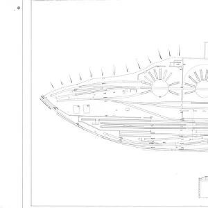
This image depicts a historical railway map titled "North Eastern Railway, Manors to Quayside. " The map is intricately detailed, showing the layout of tracks and platforms along with their respective labels. It appears to be an engineering or planning document, given its precise nature and the inclusion of technical details such as track alignments and infrastructure. The River Tyne is indicated at the top edge of the map, providing geographical context for the railway's location. The various lines crisscrossing each other suggest a complex network designed to handle multiple routes or connections within this particular area. This level of detail would have been essential for those managing or working on the railway system during its operational period. The monochrome color scheme suggests that it may be quite old; these types of maps were commonly used in late 19th century through mid-20th century railroading before digital systems became prevalent. Overall, this image captures a snapshot in time when railways were meticulously planned out by hand and served as vital arteries for transportation and commerce.
MADE IN THE USA
Safe Shipping with 30 Day Money Back Guarantee
FREE PERSONALISATION*
We are proud to offer a range of customisation features including Personalised Captions, Color Filters and Picture Zoom Tools
SECURE PAYMENTS
We happily accept a wide range of payment options so you can pay for the things you need in the way that is most convenient for you
* Options may vary by product and licensing agreement. Zoomed Pictures can be adjusted in the Cart.
![N. E. R Alnmouth [Bilton] Engine Shed [1887]](/sq/229/n-e-r-alnmouth-bilton-engine-shed-1887-14753430.jpg.webp)
![Staines & West Drayton Railway - Bridge over L&SW Railway [N. D]](/sq/229/staines-west-drayton-railway-bridge-lsw-13120137.jpg.webp)
![N. E. R Central Station Newcastle - Roof Plan [1892]](/sq/229/n-e-r-central-station-newcastle-roof-plan-13276391.jpg.webp)
![N. E. R Alnmouth Station Plan [c1909]](/sq/229/n-e-r-alnmouth-station-plan-c1909-14743612.jpg.webp)
![N. E. R Alnmouth [Bilton] Engine Shed - Roof Details [1887]](/sq/229/n-e-r-alnmouth-bilton-engine-shed-roof-14753432.jpg.webp)
![N. E. R Alnmouth [Bilton] Engine Shed - Proposed Extension Roof Details [1887]](/sq/229/n-e-r-alnmouth-bilton-engine-shed-proposed-14753434.jpg.webp)
![Metrocentre Station Gateshead Coach Station and Bridge [1989]](/sq/229/metrocentre-station-gateshead-coach-station-19579487.jpg.webp)