Metal Print > Europe > United Kingdom > England > London > River Thames
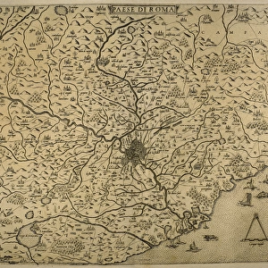
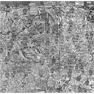
Metal Print : Map of London by John Rocque, 1745


![]()
Metal Prints From Mary Evans Picture Library
Map of London by John Rocque, 1745
Map of London by John Rocque, 1745.
1745
Mary Evans Picture Library makes available wonderful images created for people to enjoy over the centuries
Media ID 23101828
© Mary Evans Picture Library
1740s 1745 Capital Maps Rocque
16"x24" (61x41cm) Metal Print
Experience the rich history of London with our stunning Metal Prints featuring the iconic Map of London by John Rocque, 1745 from Mary Evans Picture Library. This exquisite map, published over 250 years ago, offers a fascinating glimpse into the past with its intricate details and accurate depiction of the city's layout during the Georgian era. Our high-quality Metal Prints bring out the vibrant colors and intricate lines of this historical masterpiece, making it a beautiful addition to any home or office. Each print is meticulously crafted using premium metal sheets coated with a special protective layer, ensuring long-lasting durability and a stunning, glossy finish. Elevate your space with a piece of London's history that is as timeless as it is captivating.
Made with durable metal and luxurious printing techniques, our metal photo prints go beyond traditional canvases, adding a cool, modern touch to your space. Wall mount on back. Eco-friendly 100% post-consumer recycled ChromaLuxe aluminum surface. The thickness of the print is 0.045". Featuring a Scratch-resistant surface and Rounded corners. Backing hangers are attached to the back of the print and float the print 1/2-inch off the wall when hung, the choice of hanger may vary depending on size and International orders will come with Float Mount hangers only. Finished with a brilliant white high gloss surface for unsurpassed detail and vibrance. Printed using Dye-Sublimation and for best care we recommend a non-ammonia glass cleaner, water, or isopropyl (rubbing) alcohol to prevent harming the print surface. We recommend using a clean, lint-free cloth to wipe off the print. The ultra-hard surface is scratch-resistant, waterproof and weatherproof. Avoid direct sunlight exposure.
Made with durable metal and luxurious printing techniques, metal prints bring images to life and add a modern touch to any space
Estimated Product Size is 61.5cm x 41.2cm (24.2" x 16.2")
These are individually made so all sizes are approximate
Artwork printed orientated as per the preview above, with landscape (horizontal) orientation to match the source image.
FEATURES IN THESE COLLECTIONS
> Mary Evans Prints Online
> New Images August 2021
> Arts
> Artists
> R
> John Rocque
> Arts
> Landscape paintings
> Waterfall and river artworks
> River artworks
> Europe
> United Kingdom
> England
> London
> River Thames
> Maps and Charts
> Related Images
EDITORS COMMENTS
This stunning map print, titled "A New and Correct Map of the Cities of London and Westminster, and the Borough of Southwark," was created by renowned English cartographer John Rocque in 1745. The map offers a detailed and accurate representation of London during the 1740s, showcasing the city's intricate street layout, topography, and significant landmarks. The Thames River, a vital artery of London, runs through the heart of the map, with its winding path marked by the precise placement of bridges and wharves. The city's iconic buildings, such as St. Paul's Cathedral, Westminster Abbey, and the Tower of London, are clearly depicted, providing a glimpse into London's rich history. The map also highlights the city's diverse neighborhoods, including the fashionable areas of Mayfair and Covent Garden, as well as the bustling markets and industries of Smithfield and Billingsgate. The meticulous attention to detail is evident in the inclusion of parks, churches, schools, and even individual houses. John Rocque was a pioneer in the field of topographical mapping, using the most up-to-date information and surveying techniques to create accurate and visually appealing maps. This map of London, produced in 1745, is a testament to his skill and dedication. It offers a fascinating glimpse into the past, allowing us to explore the streets and landmarks of London as they appeared over 275 years ago.
MADE IN THE USA
Safe Shipping with 30 Day Money Back Guarantee
FREE PERSONALISATION*
We are proud to offer a range of customisation features including Personalised Captions, Color Filters and Picture Zoom Tools
SECURE PAYMENTS
We happily accept a wide range of payment options so you can pay for the things you need in the way that is most convenient for you
* Options may vary by product and licensing agreement. Zoomed Pictures can be adjusted in the Basket.