Home > Europe > Italy > Lazio > Rome
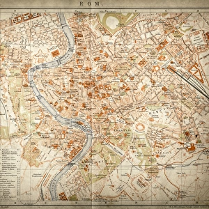
Map of city of Rome. Italian engraving. 16th century

![]()
Wall Art and Photo Gifts from Mary Evans Picture Library
Map of city of Rome. Italian engraving. 16th century
Mary Evans Picture Library makes available wonderful images created for people to enjoy over the centuries
Media ID 14337072
© Thaliastock / Mary Evans
1543 Cartography Harbor Haven Mapping Mediterranean
FEATURES IN THESE COLLECTIONS
> Europe
> Italy
> Lazio
> Rome
> Maps and Charts
> Early Maps
> Maps and Charts
> Italy
EDITORS COMMENTS
This exquisite 16th century engraving presents a detailed and captivating view of the ancient city of Rome as it appeared during the height of the Renaissance era. Dated to 1543, this Italian masterpiece showcases the city's rich history and cultural significance during a time when cartography was undergoing a revolutionary transformation. The map, meticulously etched onto the parchment, reveals the urban landscape of Rome with an impressive level of accuracy and detail. The Tiber River winds its way through the city, flowing past iconic landmarks such as the Colosseum, Pantheon, and the Vatican City. The harbor and port areas, marked as "Portus" and "Molo," are depicted with ships and boats anchored, reflecting Rome's strategic location on the Mediterranean Sea. The map also highlights the city's cardinal directions, with "North" indicated at the top, and the various districts and neighborhoods are clearly labeled. The intricate detailing of the map's borders and the elegant typography of the inscriptions add to its aesthetic appeal. This engraving is a testament to the advancements in cartography during the Modern Age, as well as a snapshot of Rome's history during the 16th century. It offers a fascinating glimpse into the past, transporting us back to a time when the city was at the center of the European cultural and artistic world.
MADE IN THE USA
Safe Shipping with 30 Day Money Back Guarantee
FREE PERSONALISATION*
We are proud to offer a range of customisation features including Personalised Captions, Color Filters and Picture Zoom Tools
SECURE PAYMENTS
We happily accept a wide range of payment options so you can pay for the things you need in the way that is most convenient for you
* Options may vary by product and licensing agreement. Zoomed Pictures can be adjusted in the Cart.