Metal Print > Europe > France > Canton > Landes
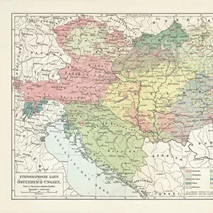
Metal Print : Map of Third Crusade and Childrens Crusade


![]()
Metal Prints From Mary Evans Picture Library
Map of Third Crusade and Childrens Crusade
Map of the Third Crusade and the Childrens Crusade, showing various routes and territories. Date: 1190
Mary Evans Picture Library makes available wonderful images created for people to enjoy over the centuries
Media ID 23265648
© Mary Evans Picture Library
12th Conflict Crete Cyprus Hungary Invasion Mediterranean Moslem Muslim Power Saladin Sicily Struggle Wars
16"x24" (61x41cm) Metal Print
Step back in time with our stunning Metal Print of the Map of the Third Crusade and Children's Crusade from Media Storehouse. This intricately detailed map, sourced from the extensive collection at Mary Evans Prints Online, takes you on a journey through history as you explore the routes and territories of the Third Crusade and the Children's Crusade in 1190. Each Metal Print is meticulously crafted, giving the image a unique, three-dimensional look that adds depth and texture to your home or office decor. With its rich, vibrant colors and high-quality finish, this map is sure to be a conversation starter and a beautiful addition to any space. Order yours today and let history come alive in your home!
Made with durable metal and luxurious printing techniques, our metal photo prints go beyond traditional canvases, adding a cool, modern touch to your space. Wall mount on back. Eco-friendly 100% post-consumer recycled ChromaLuxe aluminum surface. The thickness of the print is 0.045". Featuring a Scratch-resistant surface and Rounded corners. Backing hangers are attached to the back of the print and float the print 1/2-inch off the wall when hung, the choice of hanger may vary depending on size and International orders will come with Float Mount hangers only. Finished with a brilliant white high gloss surface for unsurpassed detail and vibrance. Printed using Dye-Sublimation and for best care we recommend a non-ammonia glass cleaner, water, or isopropyl (rubbing) alcohol to prevent harming the print surface. We recommend using a clean, lint-free cloth to wipe off the print. The ultra-hard surface is scratch-resistant, waterproof and weatherproof. Avoid direct sunlight exposure.
Made with durable metal and luxurious printing techniques, metal prints bring images to life and add a modern touch to any space
Estimated Product Size is 61.5cm x 41.2cm (24.2" x 16.2")
These are individually made so all sizes are approximate
Artwork printed orientated as per the preview above, with landscape (horizontal) orientation to match the source image.
FEATURES IN THESE COLLECTIONS
> Asia
> Cyprus
> Related Images
> Europe
> France
> Canton
> Landes
> Europe
> Greece
> Related Images
> Europe
> Hungary
> Related Images
EDITORS COMMENTS
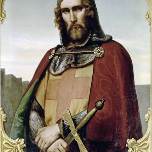
This map print depicts the significant events of the Third Crusade and the Children's Crusade during the 12th century. The Third Crusade, initiated in 1189, was a major European response to the fall of Jerusalem to Saladin, the Muslim sultan. The map illustrates the various routes taken by the crusading armies from Europe, including those led by King Richard I of England, Frederick Barbarossa of Germany, and Philip II of France. The map also highlights the territories of the Eastern Roman Empire, the Holy Land, and the Mediterranean, showcasing the strategic locations of Sicily, Crete, Greece, and Cyprus. The Children's Crusade, an extraordinary event that took place in 1212, is also depicted on this map. Thousands of children, led by two young shepherds, embarked on a journey from Europe with the hope of reaching the Holy Land and liberating it from Muslim rule. Although the outcome of their journey was not as successful as they had hoped, their determination and faith remain an inspiring testament to the spiritual fervor of the era. The map also highlights the power struggles and conflicts between Christian and Muslim forces in the Middle East, as well as the role of key players such as the Byzantine Empire and the Ayyubid Dynasty. This intricately detailed map print offers a captivating glimpse into the rich history of the 12th century, a time marked by religious war, invasion, and the struggle for power and territory in Europe and the Mediterranean.
MADE IN THE USA
Safe Shipping with 30 Day Money Back Guarantee
FREE PERSONALISATION*
We are proud to offer a range of customisation features including Personalised Captions, Color Filters and Picture Zoom Tools
SECURE PAYMENTS
We happily accept a wide range of payment options so you can pay for the things you need in the way that is most convenient for you
* Options may vary by product and licensing agreement. Zoomed Pictures can be adjusted in the Basket.