Metal Print > Europe > Russia > Related Images
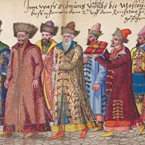
Metal Print : Moschoviae Tabula. Map of Russia and of the Indo-European


![]()
Metal Prints From Mary Evans Picture Library
Moschoviae Tabula. Map of Russia and of the Indo-European
Mary Evans Picture Library makes available wonderful images created for people to enjoy over the centuries
Media ID 8269977
© Mary Evans Picture Library 2015 - https://copyrighthub.org/s0/hub1/creation/maryevans/MaryEvansPictureID/10686815
Battista Believed Descriptions Indo Oldest Paolo Shores Tabula Villages Volga Agnese Giovio Made
16"x20" (51x41cm) Metal Print
Discover history in a new light with Media Storehouse's Metal Prints featuring the intricately detailed Moschoviae Tabula, a rare map from the Mary Evans Prints Online archive. This captivating representation of Russia and the Indo-European region, rights managed from Mary Evans Prints Online, is meticulously transferred onto high-quality metal, resulting in a stunning, vibrant, and long-lasting piece. Each Metal Print showcases the intricate lines and colors of the map, bringing history to life in a unique and modern way. Perfect for history enthusiasts, world travelers, or anyone seeking to add a touch of history to their home or office decor. Order now and let this beautiful piece of history tell its story in your space.
Made with durable metal and luxurious printing techniques, our metal photo prints go beyond traditional canvases, adding a cool, modern touch to your space. Wall mount on back. Eco-friendly 100% post-consumer recycled ChromaLuxe aluminum surface. The thickness of the print is 0.045". Featuring a Scratch-resistant surface and Rounded corners. Backing hangers are attached to the back of the print and float the print 1/2-inch off the wall when hung, the choice of hanger may vary depending on size and International orders will come with Float Mount hangers only. Finished with a brilliant white high gloss surface for unsurpassed detail and vibrance. Printed using Dye-Sublimation and for best care we recommend a non-ammonia glass cleaner, water, or isopropyl (rubbing) alcohol to prevent harming the print surface. We recommend using a clean, lint-free cloth to wipe off the print. The ultra-hard surface is scratch-resistant, waterproof and weatherproof. Avoid direct sunlight exposure.
Made with durable metal and luxurious printing techniques, metal prints bring images to life and add a modern touch to any space
Estimated Image Size (if not cropped) is 50.8cm x 40.6cm (20" x 16")
Estimated Product Size is 51.4cm x 41.2cm (20.2" x 16.2")
These are individually made so all sizes are approximate
Artwork printed orientated as per the preview above, with landscape (horizontal) orientation to match the source image.
EDITORS COMMENTS
Moschoviae Tabula: A Glimpse into the Past - An intriguing and captivating map, the Moschoviae Tabula, presents a unique blend of geography, history, and artistry. Believed to have been created around 1540, this map is considered one of the oldest known representations of Russia and the Indo-European region. The map was made during the height of the Italian Renaissance by the renowned cartographer Battista Agnese and the scholar Paolo Giovio. The map is a miniature masterpiece, measuring only 12.5 x 17.5 cm, and is painted on vellum. It is a testament to the advanced cartographic knowledge of the time, with accurate depictions of the Volga River, the Caspian Sea, and various villages and shores along the Indo-European border. Moschoviae Tabula is particularly noteworthy for its detailed descriptions of the lands and peoples of the region. The map includes annotations in Latin, providing information on the various tribes, cities, and territories. The map also features the image of a griffin, a mythical creature symbolizing power and authority, at the top left corner. The map's intricate design and historical significance make it a valuable addition to any collection of historical maps or European art. It offers a fascinating glimpse into the past, providing insights into the geography, culture, and knowledge of the Indo-European region during the Renaissance era. The Moschoviae Tabula is a testament to the ingenuity and curiosity of the scholars and cartographers of the time, and serves as a reminder of the rich history and cultural exchange that characterized the European Renaissance.
MADE IN THE USA
Safe Shipping with 30 Day Money Back Guarantee
FREE PERSONALISATION*
We are proud to offer a range of customisation features including Personalised Captions, Color Filters and Picture Zoom Tools
SECURE PAYMENTS
We happily accept a wide range of payment options so you can pay for the things you need in the way that is most convenient for you
* Options may vary by product and licensing agreement. Zoomed Pictures can be adjusted in the Basket.