Jigsaw Puzzle > Europe > Russia > Related Images
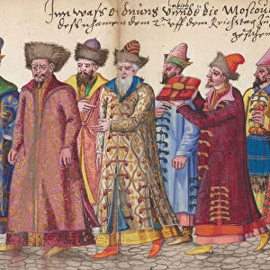
Jigsaw Puzzle : Moschoviae Tabula. Map of Russia and of the Indo-European


![]()
Jigsaw Puzzles From Mary Evans Picture Library
Moschoviae Tabula. Map of Russia and of the Indo-European
Mary Evans Picture Library makes available wonderful images created for people to enjoy over the centuries
Media ID 8269977
© Mary Evans Picture Library 2015 - https://copyrighthub.org/s0/hub1/creation/maryevans/MaryEvansPictureID/10686815
Battista Believed Descriptions Indo Oldest Paolo Shores Tabula Villages Volga Agnese Giovio Made
Jigsaw Puzzle (520 Pieces)
Discover the captivating world of history with our exquisite selection of jigsaw puzzles from Media Storehouse. Our latest addition, the "Moschoviae Tabula. Map of Russia and of the Indo-European," is a fascinating puzzle that transports you to an era of exploration and cartography. This intricately detailed puzzle, derived from an antique map published in 1676, showcases the geography of Russia and the Indo-European region as it was once understood. With Rights Managed from Mary Evans Prints Online, this jigsaw puzzle not only provides a fun and engaging challenge but also serves as a beautiful piece of decor once completed. Immerse yourself in history, and let this puzzle be the key to unlocking a world of knowledge and wonder.
Made in the USA, 520-piece puzzles measure 16" x 20" (40.6 x 50.8 cm). Every puzzle is meticulously printed on glossy photo paper, which has a strong 1.33 mm thickness. Delivered in a black storage cardboard box, these puzzles are both stylish and practical. (Note: puzzles contain small parts and are not suitable for children under 3 years of age.)
Jigsaw Puzzles are an ideal gift for any occasion
Estimated Product Size is 50.8cm x 40.5cm (20" x 15.9")
These are individually made so all sizes are approximate
Artwork printed orientated as per the preview above, with landscape (horizontal) or portrait (vertical) orientation to match the source image.
EDITORS COMMENTS
Moschoviae Tabula: A Glimpse into the Past - An intriguing and captivating map, the Moschoviae Tabula, presents a unique blend of geography, history, and artistry. Believed to have been created around 1540, this map is considered one of the oldest known representations of Russia and the Indo-European region. The map was made during the height of the Italian Renaissance by the renowned cartographer Battista Agnese and the scholar Paolo Giovio. The map is a miniature masterpiece, measuring only 12.5 x 17.5 cm, and is painted on vellum. It is a testament to the advanced cartographic knowledge of the time, with accurate depictions of the Volga River, the Caspian Sea, and various villages and shores along the Indo-European border. Moschoviae Tabula is particularly noteworthy for its detailed descriptions of the lands and peoples of the region. The map includes annotations in Latin, providing information on the various tribes, cities, and territories. The map also features the image of a griffin, a mythical creature symbolizing power and authority, at the top left corner. The map's intricate design and historical significance make it a valuable addition to any collection of historical maps or European art. It offers a fascinating glimpse into the past, providing insights into the geography, culture, and knowledge of the Indo-European region during the Renaissance era. The Moschoviae Tabula is a testament to the ingenuity and curiosity of the scholars and cartographers of the time, and serves as a reminder of the rich history and cultural exchange that characterized the European Renaissance.
MADE IN THE USA
Safe Shipping with 30 Day Money Back Guarantee
FREE PERSONALISATION*
We are proud to offer a range of customisation features including Personalised Captions, Color Filters and Picture Zoom Tools
SECURE PAYMENTS
We happily accept a wide range of payment options so you can pay for the things you need in the way that is most convenient for you
* Options may vary by product and licensing agreement. Zoomed Pictures can be adjusted in the Basket.