Metal Print > Europe > United Kingdom > Wales > Powys > Montgomery
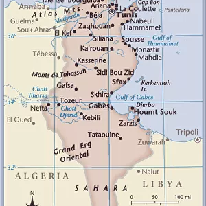
Metal Print : Mareth Line, Tunisia, by G. H. Davis


![]()
Metal Prints From Mary Evans Picture Library
Mareth Line, Tunisia, by G. H. Davis
A large-scale contour map of the complicated Mareth Line in Tunisia, North Africa, where General Montgomery stated that the enemys fate would be decided. It was the tactical objective of Allied operations at this stage of the Second World War. Date: 1943
Mary Evans Picture Library makes available wonderful images created for people to enjoy over the centuries
Media ID 14125816
© Illustrated London News Ltd/Mary Evans
1943 Allied Allies Contour Davis Decided Djerba Enemy Fate Germans Gulf Maps Montgomery Operations Scale Strategy Tactical Tunisia Tunisian Gabes Objective
16"x20" (51x41cm) Metal Print
Experience the historical depth of Mareth Line, Tunisia with our stunning Metal Prints from Media Storehouse. This captivating image, captured by G. H. Davis and sourced from Mary Evans Prints Online, showcases a large-scale contour map of the intricate Mareth Line. Witness the complexity of this strategic location in North Africa, where General Montgomery famously declared the enemy's fate would be decided. Our Metal Prints bring historical moments to life with their vibrant colors and exceptional detail, making for a truly unique and captivating addition to your home or office decor.
Made with durable metal and luxurious printing techniques, our metal photo prints go beyond traditional canvases, adding a cool, modern touch to your space. Wall mount on back. Eco-friendly 100% post-consumer recycled ChromaLuxe aluminum surface. The thickness of the print is 0.045". Featuring a Scratch-resistant surface and Rounded corners. Backing hangers are attached to the back of the print and float the print 1/2-inch off the wall when hung, the choice of hanger may vary depending on size and International orders will come with Float Mount hangers only. Finished with a brilliant white high gloss surface for unsurpassed detail and vibrance. Printed using Dye-Sublimation and for best care we recommend a non-ammonia glass cleaner, water, or isopropyl (rubbing) alcohol to prevent harming the print surface. We recommend using a clean, lint-free cloth to wipe off the print. The ultra-hard surface is scratch-resistant, waterproof and weatherproof. Avoid direct sunlight exposure.
Made with durable metal and luxurious printing techniques, metal prints bring images to life and add a modern touch to any space
Estimated Image Size (if not cropped) is 40.6cm x 50.8cm (16" x 20")
Estimated Product Size is 41.2cm x 51.4cm (16.2" x 20.2")
These are individually made so all sizes are approximate
Artwork printed orientated as per the preview above, with portrait (vertical) orientation to match the source image.
FEATURES IN THESE COLLECTIONS
> Africa
> Tunisia
> Related Images
> Europe
> France
> Canton
> Allier
> Europe
> France
> Canton
> Landes
> Europe
> United Kingdom
> Wales
> Powys
> Montgomery
> Historic
> World War I and II
> Generals and leaders
> Maps and Charts
> Early Maps
EDITORS COMMENTS
This large-scale contour map, created by G.H. Davis in 1943, depicts the intricate Mareth Line in Tunisia, North Africa, a strategic position that became the tactical objective of Allied operations during the Second World War. The Mareth Line was a series of fortifications and defensive positions extending from the Gulf of Gabes to the Mediterranean Sea, and was the Germans' final defensive line in Tunisia before their retreat. The line was named after the nearby town of Mareth, and was considered a formidable obstacle due to its natural defenses, including mountains, islands, and the Bou Grara and Grara rivers. At the time this map was made, the outcome of the war in North Africa was uncertain, and the fate of the Axis powers in the region was a topic of intense debate. Allied Commander-in-Chief, General Bernard Montgomery, famously declared that the enemy's fate would be decided at the Mareth Line. The Allied forces launched a series of attacks against the position, culminating in the Battle of Wadi Akarit in March 1943, which ultimately led to the German retreat and the end of the Tunisian campaign. This map provides a detailed view of the complex terrain and strategic features of the Mareth Line, including the Djerba Island, the mountains, and the various fortifications and defensive positions. It is an invaluable historical document, offering insights into the military strategy and tactics employed by both sides during the North African campaign of the Second World War.
MADE IN THE USA
Safe Shipping with 30 Day Money Back Guarantee
FREE PERSONALISATION*
We are proud to offer a range of customisation features including Personalised Captions, Color Filters and Picture Zoom Tools
SECURE PAYMENTS
We happily accept a wide range of payment options so you can pay for the things you need in the way that is most convenient for you
* Options may vary by product and licensing agreement. Zoomed Pictures can be adjusted in the Basket.