Metal Print > Asia > China > Maps
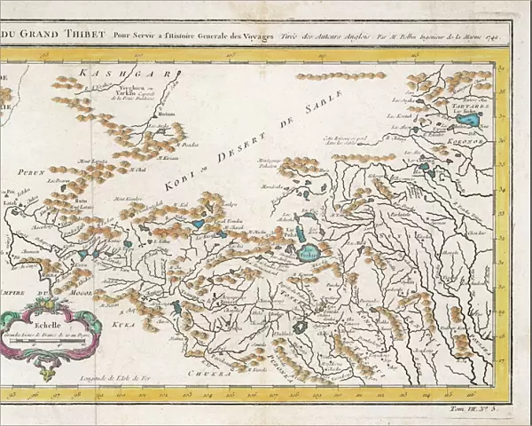
Metal Print : Map / China / Tibet 1749


![]()
Metal Prints from Mary Evans Picture Library
Map / China / Tibet 1749
CARTE DU GRAND THIBET scale in French leagues
Mary Evans Picture Library makes available wonderful images created for people to enjoy over the centuries
Media ID 576021
© Mary Evans Picture Library 2015 - https://copyrighthub.org/s0/hub1/creation/maryevans/MaryEvansPictureID/10014082
1749 Carte Leagues Maps Scale Tibet Thibet
16"x20" (51x41cm) Metal Print
Discover the captivating beauty of ancient maps with our Media Storehouse Metal Prints featuring the intricately detailed "Map of Grand Tibet" from Mary Evans Picture Library. This exquisite 1749 map, originally published in French leagues, showcases the vast expanse of China and Tibet with meticulous precision. Each Metal Print is crafted with the highest quality materials, ensuring a vibrant, long-lasting display. Bring history to life in your home or office with this stunning and unique piece.
Made with durable metal and luxurious printing techniques, our metal photo prints go beyond traditional canvases, adding a cool, modern touch to your space. Wall mount on back. Eco-friendly 100% post-consumer recycled ChromaLuxe aluminum surface. The thickness of the print is 0.045". Featuring a Scratch-resistant surface and Rounded corners. Backing hangers are attached to the back of the print and float the print 1/2-inch off the wall when hung, the choice of hanger may vary depending on size and International orders will come with Float Mount hangers only. Finished with a brilliant white high gloss surface for unsurpassed detail and vibrance. Printed using Dye-Sublimation and for best care we recommend a non-ammonia glass cleaner, water, or isopropyl (rubbing) alcohol to prevent harming the print surface. We recommend using a clean, lint-free cloth to wipe off the print. The ultra-hard surface is scratch-resistant, waterproof and weatherproof. Avoid direct sunlight exposure.
Made with durable metal and luxurious printing techniques, metal prints bring images to life and add a modern touch to any space
Estimated Image Size (if not cropped) is 50.8cm x 40.6cm (20" x 16")
Estimated Product Size is 51.4cm x 41.2cm (20.2" x 16.2")
These are individually made so all sizes are approximate
Artwork printed orientated as per the preview above, with landscape (horizontal) orientation to match the source image.
FEATURES IN THESE COLLECTIONS
> Mary Evans Prints Online
> Maps
> Asia
> Related Images
> Maps and Charts
> Early Maps
> Maps and Charts
> Related Images
EDITORS COMMENTS
This stunning print of a historical map from 1749 showcases the intricate details of China and Tibet, providing a glimpse into the past and the geographical landscape of Asia during that time. The scale in French leagues adds an interesting touch to this beautifully preserved piece of history.
The intricacies of the map, from the borders delineating different regions to the rivers snaking through the land, offer a fascinating insight into how these areas were perceived and understood centuries ago. The inclusion of Tibet on this map is particularly noteworthy, as it highlights its significance within the region even back in 1749.
As we gaze upon this ancient cartographic masterpiece, we are transported back in time to an era when exploration and discovery were at their peak. The attention to detail and precision with which this map was created is truly remarkable, showcasing the skill and artistry of cartographers from centuries past.
Whether you are a history buff, a geography enthusiast, or simply appreciate fine craftsmanship, this print is sure to captivate your imagination and spark your curiosity about bygone eras. Let yourself be drawn into the world of 18th-century cartography with this exquisite piece from Mary Evans Picture Library.
MADE IN THE USA
Safe Shipping with 30 Day Money Back Guarantee
FREE PERSONALISATION*
We are proud to offer a range of customisation features including Personalised Captions, Color Filters and Picture Zoom Tools
SECURE PAYMENTS
We happily accept a wide range of payment options so you can pay for the things you need in the way that is most convenient for you
* Options may vary by product and licensing agreement. Zoomed Pictures can be adjusted in the Cart.