Canvas Print > Asia > China > Maps
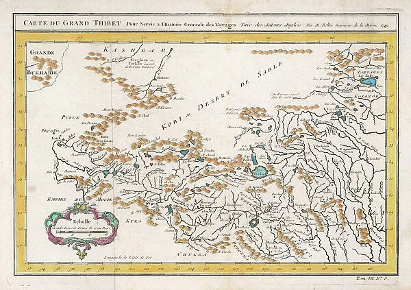
Canvas Print : Map / China / Tibet 1749


![]()
Canvas Prints from Mary Evans Picture Library
Map / China / Tibet 1749
CARTE DU GRAND THIBET scale in French leagues
Mary Evans Picture Library makes available wonderful images created for people to enjoy over the centuries
Media ID 576021
© Mary Evans Picture Library 2015 - https://copyrighthub.org/s0/hub1/creation/maryevans/MaryEvansPictureID/10014082
1749 Carte Leagues Maps Scale Tibet Thibet
20"x16" (51x41cm) Canvas Print
Discover the captivating allure of the past with our exquisite selection of Canvas Prints from the Media Storehouse range. Feast your eyes on this stunning representation of "Map / China / Tibet 1749" by Mary Evans Picture Library from Mary Evans Prints Online. This intricately detailed map, originally published in French leagues, transports you back to the 18th century with its captivating depiction of China and Tibet. Each canvas print is meticulously crafted using premium materials, ensuring vibrant colors and sharp details that bring history to life in your home or office. Elevate your decor while expanding your knowledge with this beautiful and educational addition to your space.
Delivered stretched and ready to hang our premium quality canvas prints are made from a polyester/cotton blend canvas and stretched over a 1.25" (32mm) kiln dried knot free wood stretcher bar. Packaged in a plastic bag and secured to a cardboard insert for safe transit.
Canvas Prints add colour, depth and texture to any space. Professionally Stretched Canvas over a hidden Wooden Box Frame and Ready to Hang
Estimated Product Size is 50.8cm x 40.6cm (20" x 16")
These are individually made so all sizes are approximate
Artwork printed orientated as per the preview above, with landscape (horizontal) orientation to match the source image.
FEATURES IN THESE COLLECTIONS
> Asia
> Related Images
> Maps and Charts
> Early Maps
> Maps and Charts
> Related Images
> Mary Evans Prints Online
> Maps
EDITORS COMMENTS
This stunning print of a historical map from 1749 showcases the intricate details of China and Tibet, providing a glimpse into the past and the geographical landscape of Asia during that time. The scale in French leagues adds an interesting touch to this beautifully preserved piece of history.
The intricacies of the map, from the borders delineating different regions to the rivers snaking through the land, offer a fascinating insight into how these areas were perceived and understood centuries ago. The inclusion of Tibet on this map is particularly noteworthy, as it highlights its significance within the region even back in 1749.
As we gaze upon this ancient cartographic masterpiece, we are transported back in time to an era when exploration and discovery were at their peak. The attention to detail and precision with which this map was created is truly remarkable, showcasing the skill and artistry of cartographers from centuries past.
Whether you are a history buff, a geography enthusiast, or simply appreciate fine craftsmanship, this print is sure to captivate your imagination and spark your curiosity about bygone eras. Let yourself be drawn into the world of 18th-century cartography with this exquisite piece from Mary Evans Picture Library.
MADE IN THE USA
Safe Shipping with 30 Day Money Back Guarantee
FREE PERSONALISATION*
We are proud to offer a range of customisation features including Personalised Captions, Color Filters and Picture Zoom Tools
SECURE PAYMENTS
We happily accept a wide range of payment options so you can pay for the things you need in the way that is most convenient for you
* Options may vary by product and licensing agreement. Zoomed Pictures can be adjusted in the Cart.