Metal Print > Europe > United Kingdom > England > Berkshire > Old Windsor
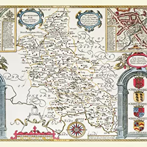
Metal Print : Old County Map of Berkshire 1611 by John Speed


Metal Prints From MapSeeker
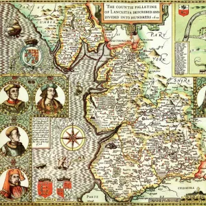
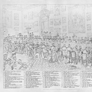
Old County Map of Berkshire 1611 by John Speed
A facimile of John Speeds historical map of Berkshire originally published for the " Theatre of the Empire of Great Britain", an atlas to accompany " a history of Great Britain".
The top of Speeds map of Berkshire is illustrated with a magnificent drawing of Windsor Castle. Speed notes that here was the headquarters of the Order of the Garter and there is a picture of James I wearing the robes and insignia of the order. There is an illustration of a battle fought at Radcott Bridge in 1387
Welcome to the Mapseeker Image library and enter an historic gateway to one of the largest on-line collections of Historic Maps, Nostalgic Views, Vista's and Panorama's from a World gone by.
Media ID 20347715
© Mapseeker Publishing Ltd
County Map County Map Of England English County Map Historic Map John Speed Map Old County Map Old English County Map Speed Map Speede Map Berkshire
16"x24" (61x41cm) Metal Print
Step back in time with our exquisite Metal Print of the Old County Map of Berkshire 1611 by John Speed from MapSeeker. This beautiful reproduction is a facsimile of the historical map originally published for the "Theatre of the Empire of Great Britain," an atlas accompanying "A History of Great Britain." The intricate details of the map are brought to life on high-quality metal, giving it a unique and eye-catching appearance. Perfect for adding a touch of history and character to any room, this metal print is not only a decorative piece but also a conversation starter. Bring the rich history of Berkshire to your home or office with this stunning and authentic reproduction.
Made with durable metal and luxurious printing techniques, our metal photo prints go beyond traditional canvases, adding a cool, modern touch to your space. Wall mount on back. Eco-friendly 100% post-consumer recycled ChromaLuxe aluminum surface. The thickness of the print is 0.045". Featuring a Scratch-resistant surface and Rounded corners. Backing hangers are attached to the back of the print and float the print 1/2-inch off the wall when hung, the choice of hanger may vary depending on size and International orders will come with Float Mount hangers only. Finished with a brilliant white high gloss surface for unsurpassed detail and vibrance. Printed using Dye-Sublimation and for best care we recommend a non-ammonia glass cleaner, water, or isopropyl (rubbing) alcohol to prevent harming the print surface. We recommend using a clean, lint-free cloth to wipe off the print. The ultra-hard surface is scratch-resistant, waterproof and weatherproof. Avoid direct sunlight exposure.
Made with durable metal and luxurious printing techniques, metal prints bring images to life and add a modern touch to any space
Estimated Product Size is 61.5cm x 41.2cm (24.2" x 16.2")
These are individually made so all sizes are approximate
Artwork printed orientated as per the preview above, with landscape (horizontal) orientation to match the source image.
FEATURES IN THESE COLLECTIONS
> MapSeeker
> Maps from the British Isles
> England and Counties PORTFOLIO
> Architecture
> Great Houses
> Windsor Castle
> Arts
> Artists
> S
> John Speed
> Europe
> United Kingdom
> England
> Berkshire
> Old Windsor
> Europe
> United Kingdom
> England
> Berkshire
> Related Images
> Europe
> United Kingdom
> England
> Berkshire
> Windsor
> Europe
> United Kingdom
> England
> Castles
> Europe
> United Kingdom
> England
> Maps
> Historic
> Medieval architecture
> Castles and fortresses
> Historic castles
> Maps and Charts
> British Empire Maps
> Maps and Charts
> Early Maps
EDITORS COMMENTS
This print showcases an exquisite piece of history - the "Old County Map of Berkshire 1611" by John Speed. Originally published for the renowned "Theatre of the Empire of Great Britain" this map is a facsimile from Speed's atlas accompanying "A History of Great Britain". Atop this remarkable map, one's eyes are immediately drawn to a magnificent illustration of Windsor Castle. As noted by Speed himself, this iconic castle served as the headquarters for the prestigious Order of the Garter. The image also features a depiction of James I adorned in the robes and insignia emblematic of this esteemed order. Adding further intrigue to this historical gem, there is an illustration depicting a significant battle fought at Radcott Bridge in 1387. This detail provides us with a glimpse into past conflicts that shaped Berkshire's rich heritage. With its intricate details and meticulous craftsmanship, this old county map offers viewers an opportunity to immerse themselves in centuries gone by. It serves as both a testament to John Speed's cartographic expertise and as a valuable resource for those seeking insights into Berkshire's history. Whether you're fascinated by old English county maps or simply appreciate historical artifacts, this print invites you on an enchanting journey through time. Discover Berkshire anew with John Speed as your guide!
MADE IN THE USA
Safe Shipping with 30 Day Money Back Guarantee
FREE PERSONALISATION*
We are proud to offer a range of customisation features including Personalised Captions, Color Filters and Picture Zoom Tools
SECURE PAYMENTS
We happily accept a wide range of payment options so you can pay for the things you need in the way that is most convenient for you
* Options may vary by product and licensing agreement. Zoomed Pictures can be adjusted in the Basket.