Fine Art Print > Europe > United Kingdom > England > Berkshire > Old Windsor
Fine Art Print : Old County Map of Berkshire 1611 by John Speed


Fine Art Prints From MapSeeker
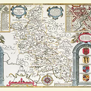
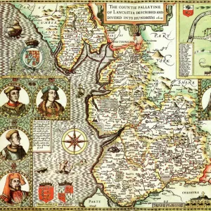
Old County Map of Berkshire 1611 by John Speed
A facimile of John Speeds historical map of Berkshire originally published for the " Theatre of the Empire of Great Britain", an atlas to accompany " a history of Great Britain".
The top of Speeds map of Berkshire is illustrated with a magnificent drawing of Windsor Castle. Speed notes that here was the headquarters of the Order of the Garter and there is a picture of James I wearing the robes and insignia of the order. There is an illustration of a battle fought at Radcott Bridge in 1387
Welcome to the Mapseeker Image library and enter an historic gateway to one of the largest on-line collections of Historic Maps, Nostalgic Views, Vista's and Panorama's from a World gone by.
Media ID 20347715
© Mapseeker Publishing Ltd
County Map County Map Of England English County Map Historic Map John Speed Map Old County Map Old English County Map Speed Map Speede Map Berkshire
21"x14" (+3" Border) Fine Art Print
Step back in time with our exquisite Old County Map of Berkshire 1611 by John Speed from our Media Storehouse Fine Art Prints collection. This historical masterpiece, a facsimile of the original map published for "Theatre of the Empire of Great Britain," offers a captivating glimpse into the past. Detailed and intricately designed, this fine art print showcases the rich history and geography of Berkshire in the early 17th century. Bring the charm of history into your home or office with this stunning, museum-quality reproduction. Order now and travel through time with every detail.
21x14 image printed on 27x20 Fine Art Rag Paper with 3" (76mm) white border. Our Fine Art Prints are printed on 300gsm 100% acid free, PH neutral paper with archival properties. This printing method is used by museums and art collections to exhibit photographs and art reproductions.
Our fine art prints are high-quality prints made using a paper called Photo Rag. This 100% cotton rag fibre paper is known for its exceptional image sharpness, rich colors, and high level of detail, making it a popular choice for professional photographers and artists. Photo rag paper is our clear recommendation for a fine art paper print. If you can afford to spend more on a higher quality paper, then Photo Rag is our clear recommendation for a fine art paper print.
Estimated Image Size (if not cropped) is 53.3cm x 35.5cm (21" x 14")
Estimated Product Size is 68.6cm x 50.8cm (27" x 20")
These are individually made so all sizes are approximate
Artwork printed orientated as per the preview above, with landscape (horizontal) orientation to match the source image.
FEATURES IN THESE COLLECTIONS
> Architecture
> Great Houses
> Windsor Castle
> Arts
> Artists
> S
> John Speed
> Europe
> United Kingdom
> England
> Berkshire
> Old Windsor
> Europe
> United Kingdom
> England
> Berkshire
> Related Images
> Europe
> United Kingdom
> England
> Berkshire
> Windsor
> Europe
> United Kingdom
> England
> Castles
> Europe
> United Kingdom
> England
> Maps
> Historic
> Medieval architecture
> Castles and fortresses
> Historic castles
> Maps and Charts
> British Empire Maps
> Maps and Charts
> Early Maps
EDITORS COMMENTS
This print showcases an exquisite piece of history - the "Old County Map of Berkshire 1611" by John Speed. Originally published for the renowned "Theatre of the Empire of Great Britain" this map is a facsimile from Speed's atlas accompanying "A History of Great Britain". Atop this remarkable map, one's eyes are immediately drawn to a magnificent illustration of Windsor Castle. As noted by Speed himself, this iconic castle served as the headquarters for the prestigious Order of the Garter. The image also features a depiction of James I adorned in the robes and insignia emblematic of this esteemed order. Adding further intrigue to this historical gem, there is an illustration depicting a significant battle fought at Radcott Bridge in 1387. This detail provides us with a glimpse into past conflicts that shaped Berkshire's rich heritage. With its intricate details and meticulous craftsmanship, this old county map offers viewers an opportunity to immerse themselves in centuries gone by. It serves as both a testament to John Speed's cartographic expertise and as a valuable resource for those seeking insights into Berkshire's history. Whether you're fascinated by old English county maps or simply appreciate historical artifacts, this print invites you on an enchanting journey through time. Discover Berkshire anew with John Speed as your guide!
MADE IN THE USA
Safe Shipping with 30 Day Money Back Guarantee
FREE PERSONALISATION*
We are proud to offer a range of customisation features including Personalised Captions, Color Filters and Picture Zoom Tools
SECURE PAYMENTS
We happily accept a wide range of payment options so you can pay for the things you need in the way that is most convenient for you
* Options may vary by product and licensing agreement. Zoomed Pictures can be adjusted in the Basket.