Metal Print > Europe > United Kingdom > England > London > Royalty
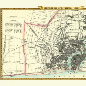
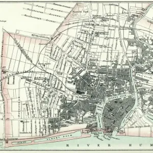
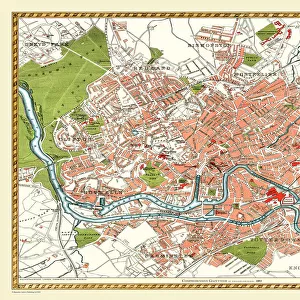
Metal Print : Old Map of Hull 1898 from the Royal Atlas by Bartholomew


![]()
Metal Prints From MapSeeker
Old Map of Hull 1898 from the Royal Atlas by Bartholomew
A fine very detailed plan of the City of Hull remastered from an original contained within " The Royal Atlas of England and Wales" ; edited by J.G. Bartholomew, published by George Newnes, Limited, London
Welcome to the Mapseeker Image library and enter an historic gateway to one of the largest on-line collections of Historic Maps, Nostalgic Views, Vista's and Panorama's from a World gone by.
Media ID 20347648
Bartholomew Bartholomew Map Historic Map Old Town Plan Royal Atlas Royal Atlas Map Hull Hull City
16"x24" (61x41cm) Metal Print
Step back in time with our exquisite Metal Print of the Old Map of Hull 1898 from the Royal Atlas by Bartholomew, available at Media Storehouse. This intricately detailed map, sourced from the original contained within "The Royal Atlas of England and Wales," edited by J.G, offers a captivating glimpse into the history of this historic city. Each metal print is meticulously remastered to bring out the finest details, resulting in a stunning and vibrant piece that is sure to make a statement in any room. The advanced printing technology used ensures that the colors remain vibrant and the details remain sharp, making this a truly unique and beautiful addition to your home or office decor. Order yours today and transport yourself back in time with this remarkable piece of cartographic history.
Made with durable metal and luxurious printing techniques, our metal photo prints go beyond traditional canvases, adding a cool, modern touch to your space. Wall mount on back. Eco-friendly 100% post-consumer recycled ChromaLuxe aluminum surface. The thickness of the print is 0.045". Featuring a Scratch-resistant surface and Rounded corners. Backing hangers are attached to the back of the print and float the print 1/2-inch off the wall when hung, the choice of hanger may vary depending on size and International orders will come with Float Mount hangers only. Finished with a brilliant white high gloss surface for unsurpassed detail and vibrance. Printed using Dye-Sublimation and for best care we recommend a non-ammonia glass cleaner, water, or isopropyl (rubbing) alcohol to prevent harming the print surface. We recommend using a clean, lint-free cloth to wipe off the print. The ultra-hard surface is scratch-resistant, waterproof and weatherproof. Avoid direct sunlight exposure.
Made with durable metal and luxurious printing techniques, metal prints bring images to life and add a modern touch to any space
Estimated Product Size is 61.5cm x 41.2cm (24.2" x 16.2")
These are individually made so all sizes are approximate
Artwork printed orientated as per the preview above, with landscape (horizontal) orientation to match the source image.
FEATURES IN THESE COLLECTIONS
> MapSeeker
> British Town And City Plans
> English & Welsh PORTFOLIO
> Arts
> Photorealistic artworks
> Detailed art pieces
> Masterful detailing in art
> Europe
> United Kingdom
> England
> London
> Royalty
> Europe
> United Kingdom
> England
> Maps
> Europe
> United Kingdom
> Wales
> Maps
> Europe
> United Kingdom
> Wales
> Posters
> Maps and Charts
> Wales
EDITORS COMMENTS
This print showcases an exquisite piece of history - the "Old Map of Hull 1898" from the renowned Royal Atlas by Bartholomew. With its fine and intricate details, this map offers a fascinating glimpse into the City of Hull during that era. Remastered from an original found within "The Royal Atlas of England and Wales" edited by J. G. Bartholomew and published by George Newnes, Limited in London, this print is a true treasure for history enthusiasts. Transporting us back to a time long gone, this old town plan reveals the layout and structure of Hull with remarkable accuracy. Every street, alleyway, building, and landmark is meticulously depicted on this historic hull map. It provides an invaluable resource for those seeking to understand how the city has evolved over time. With its rich historical significance, this royal atlas map captures not only the physical geography but also reflects the spirit and essence of Hull as it once was. Whether you are a local resident or simply intrigued by urban development throughout centuries, this stunning print will undoubtedly spark your curiosity
MADE IN THE USA
Safe Shipping with 30 Day Money Back Guarantee
FREE PERSONALISATION*
We are proud to offer a range of customisation features including Personalised Captions, Color Filters and Picture Zoom Tools
SECURE PAYMENTS
We happily accept a wide range of payment options so you can pay for the things you need in the way that is most convenient for you
* Options may vary by product and licensing agreement. Zoomed Pictures can be adjusted in the Basket.