Fraud Blocker Skip to main content

Home > Europe > United Kingdom > England > Yorkshire > Kingston upon Hull
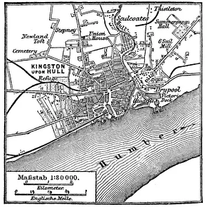
Map of Hull

 : Map of Hull
Sold 3
In Stock
We accept all major payment options so you can pay for the things you need in the way that is most convenient for you

Choose Your Product


Fine Art Storehouse Photo Prints and Wall Art

Map of Hull

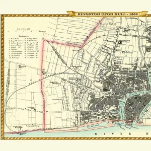
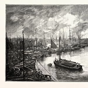
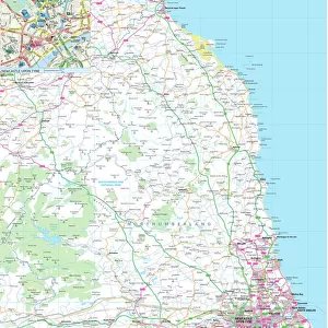
Vintage map from 1880 of Hull in the East Riding of Yorkshire, England. The city of Hull has served as market town, military supply port, trading hub, fishing and whaling centre, and industrial metropolis. Unleash your creativity and transform your space into a visual masterpiece. © duncan1890

duncan1890

Media ID 13711447

1880 1889 City Map Commercial Dock District District Type Equipment Human Settlement Image Created 1880 1889 Manufactured Object Navigational Equipment Northern Europe Objects Equipment Road Map Styles Thoroughfare Travel Locations Urban Road Yorkshire Cartography Humber River Humberside Image Created 19th Century Kingston Upon Hull Obsolete Victorian Style

FEATURES IN THESE COLLECTIONS

> Architecture > Industrial

> Arts > Contemporary art > Photography > Street art

> Europe > United Kingdom > England > East Riding of Yorkshire > Related Images

> Europe > United Kingdom > England > Humberside

> Europe > United Kingdom > England > Kingston upon Hull

> Europe > United Kingdom > England > Maps

> Europe > United Kingdom > England > Rivers

> Europe > United Kingdom > England > Yorkshire > Hull

> Europe > United Kingdom > England > Yorkshire > Kingston upon Hull

> Europe > United Kingdom > England > Yorkshire > Old Town

> Fine Art Storehouse > Map > Historical Maps

> Fine Art Storehouse > Map

SECURE PAYMENTS
We accept all major payment options so you can pay for the things you need in the way that is most convenient for you

Made in USA
Safe Shipping, Easy Returns

FREE PERSONALISATION
We are proud to offer a range of customisation including Cropping, Captions, and Filters. Zoom Cropping can be adjusted in the basket


EDITORS COMMENTS

This vintage map print takes us back to the bustling city of Hull in 1880, offering a captivating glimpse into its rich history. Serving as a market town, military supply port, trading hub, fishing and whaling center, and industrial metropolis, Hull has witnessed remarkable transformations over the years. The 19th-century style of this antique image evokes a sense of nostalgia for an era long gone by. With intricate details and Victorian aesthetics, it transports us to a time when cartography was meticulously crafted by hand. The map showcases not only the urban roads and streets but also highlights the significance of Humber River that flows through Kingston upon Hull. As we explore this snapshot from the past, we can't help but marvel at how human settlements have evolved over time. From commercial docks to distinct districts, every corner tells a story of growth and progress. Although no people are present in this photograph, their presence is felt through the navigational equipment scattered across the map - a testament to their desire for exploration and travel. This piece serves as more than just an object; it encapsulates an entire era within its frame. It reminds us that cities like Hull are shaped by their pasts while constantly adapting to new realities. As we admire this beautifully manufactured object with reverence for history's treasures, let it transport us on a journey through time where old meets new amidst an urban scene in Northern Europe's charming Yorkshire region.


Framed Prints of Map of Hull

Discover the rich history of Hull, England with our stunning Framed Print of "Map of Hull" by duncan1890 from the Media Storehouse Fine Art Storehouse collection. This vintage map, dated back to 1880, showcases the city's past as a market town, military supply port, trading hub, and fishing and whaling centre in the East Riding of Yorkshire. Add this beautiful piece to your home or office decor and transport yourself back in time. The high-quality print is carefully framed to preserve its vintage charm and is sure to make a unique and thoughtful gift for any history or geography enthusiast. Order yours today and bring a piece of the past into your space.


Photo Prints of Map of Hull

Discover the rich history of Hull, East Riding of Yorkshire, England with our exquisite "Map of Hull" print from duncan1890 in the Media Storehouse Fine Art Storehouse collection. This vintage map, dating back to 1880, beautifully illustrates Hull's significance as a market town, military supply port, trading hub, and fishing and whaling centre. Bring a piece of history into your home or office, and transport yourself back in time with this captivating and intricately detailed representation of Hull during an era of great growth and development. Order your "Map of Hull" print today and add a touch of timeless charm to your space.


Poster Prints of Map of Hull

Discover the rich history of Hull, England with our beautiful vintage Map of Hull print from the Media Storehouse Fine Art collection. This stunning piece, created by duncan1890, takes you back in time to 1880 with intricate detail and authenticity. Hull, located in the East Riding of Yorkshire, has a fascinating past as a market town, military supply port, trading hub, and fishing and whaling centre. Bring this piece home and add a touch of historical charm to your space. The high-quality print is made to last, ensuring your new treasure will be enjoyed for years to come.


Jigsaw Puzzles of Map of Hull

Discover the rich history of Hull with our captivating jigsaw puzzle from Media Storehouse, featuring the intricately detailed "Map of Hull" by duncan1890 from Fine Art Storehouse. This vintage map, dating back to 1880, showcases Hull's transformation from a market town to a military supply port, trading hub, and thriving fishing and whaling centre in the East Riding of Yorkshire, England. Bring history to life in your home as you piece together this intriguing puzzle, perfect for puzzle enthusiasts and history buffs alike. Immerse yourself in the journey as you explore the intricate details and stories hidden within the lines of this captivating puzzle.

diamond
Made With High Grade Materials
thumb_up
Professional Quality Finish
package_2
Carefully Packed To Aid Safe Arrival

You May Also Like


HULL DOCKSHULL DOCKS
Add to Basket
Old Map of Kingston Upon Hull 1862 by Fullarton & CoOld Map of Kingston Upon Hull 1862 by Fullarton & Co
Add to Basket
Kingston upon Hull EAW004505Kingston upon Hull EAW004505
Add to Basket
Kingston upon Hull EPW012805Kingston upon Hull EPW012805
Add to Basket
Humber ferry EPW036413Humber ferry EPW036413
Add to Basket
Kingston upon Hull mapKingston upon Hull map
Add to Basket
Old Map of Hull 1898 from the Royal Atlas by BartholomewOld Map of Hull 1898 from the Royal Atlas by Bartholomew
Add to Basket
Hull Monument CardHull Monument Card
Add to Basket
Hull Market PlaceHull Market Place
Add to Basket
HULL FAIR, 1905HULL FAIR, 1905
Add to Basket
Dockside scene and Vittoria Hotel, Hull, YorkshireDockside scene and Vittoria Hotel, Hull, Yorkshire
Add to Basket
QUEENs DOCK, HULL. The Port of Hull is a trading port located at the confluence of the River HullQUEENs DOCK, HULL. The Port of Hull is a trading port located at the confluence of the River Hull
Add to Basket

Gallery Wall Inspiration

Map Of New Holland
Antique map of Britain under the Anglo Saxons
Map of India 1900
Map of Dorset 1883
Antique map of the Roman Empire
Map of Middle East - illustration
Map of Cyprus, published in 1880
Antquie Map of London, 1880
Map of Anglo-Saxon Kingdoms and the Danelaw, 9th Century
Antique map of Britain under the Ancient Romans
Apostle Pauls Missionary Journeys, lithograph, published in 1886
Earth map according to Herodotus
Sicily map 1895
Battle Of Waterloo
Map of Cyprus
Antique map, Scotland, Jura, Mull, Argyll, Islay 19th Century
Map of Devon 1883
Map of Ireland 1897
Antique map of Tasmania
Ethnological map of the Austro-Hungarian Empire, lithograph, published in 1897
Cornwall map 1884
Antique map of Ireland
Old map of Australia 1899
Antique map of New Zealand in the 19th Century, 1873
Antique map of Hadrians wall
Greece at the beginning of the Peloponnesian War (431-404 BC)
Map of Portugal

Discover Our Collections


IndustrialIndustrial
View Collection
MapMap
View Collection
Kingston upon HullKingston upon Hull
View Collection
HumbersideHumberside
View Collection
HullHull
View Collection
Kingston upon HullKingston upon Hull
View Collection
Old TownOld Town
View Collection
East Riding of Yorkshire Related ImagesEast Riding of Yorkshire Related Images
View Collection
MapsMaps
View Collection
RiversRivers
View Collection
Historical MapsHistorical Maps
View Collection
Street artStreet art
View Collection


© Copyright Media Storehouse, All Rights Reserved 2003 - 2025
Facebook     Pinterest     100% Payment Secure     Reviews IO